You are here: Home > Network List > II - Global Seismograph Network (GSN - IRIS/IDA) Stations List
> Station LVZ Lovozero, Russia > Earthquake Result Viewer
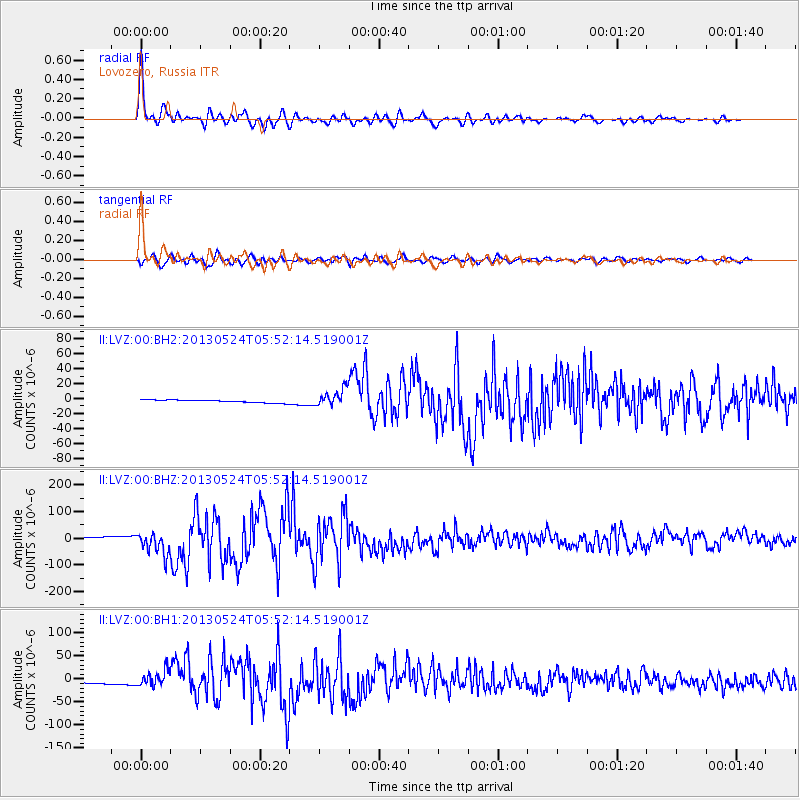
LVZ Lovozero, Russia - Earthquake Result Viewer

| Earthquake location: |
Sea Of Okhotsk |
| Earthquake latitude/longitude: |
54.9/153.2 |
| Earthquake time(UTC): |
2013/05/24 (144) 05:44:48 GMT |
| Earthquake Depth: |
598 km |
| Earthquake Magnitude: |
8.4 MW, 7.5 MB, 8.3 MW |
| Earthquake Catalog/Contributor: |
NEIC PDE/NEIC PDE-W |
|
| Network: |
II Global Seismograph Network (GSN - IRIS/IDA) |
| Station: |
LVZ Lovozero, Russia |
| Lat/Lon: |
67.90 N/34.65 E |
| Elevation: |
630 m |
|
| Distance: |
49.4 deg |
| Az: |
334.034 deg |
| Baz: |
41.943 deg |
| Ray Param: |
0.06590952 |
| Estimated Moho Depth: |
39.25 km |
| Estimated Crust Vp/Vs: |
1.60 |
| Assumed Crust Vp: |
6.367 km/s |
| Estimated Crust Vs: |
3.979 km/s |
| Estimated Crust Poisson's Ratio: |
0.18 |
|
| Radial Match: |
96.73666 % |
| Radial Bump: |
400 |
| Transverse Match: |
89.6279 % |
| Transverse Bump: |
400 |
| SOD ConfigId: |
512894 |
| Insert Time: |
2013-09-14 17:20:54.975 +0000 |
| GWidth: |
2.5 |
| Max Bumps: |
400 |
| Tol: |
0.001 |
|
Signal To Noise
| Channel | StoN | STA | LTA |
| II:LVZ:00:BHZ:20130524T05:52:14.519001Z | 9.927509 | 4.162558E-5 | 4.1929525E-6 |
| II:LVZ:00:BH1:20130524T05:52:14.519001Z | 7.3623695 | 1.6816366E-5 | 2.284097E-6 |
| II:LVZ:00:BH2:20130524T05:52:14.519001Z | 6.3701878 | 1.1516144E-5 | 1.8078185E-6 |
| Arrivals |
| Ps | 3.9 SECOND |
| PpPs | 15 SECOND |
| PsPs/PpSs | 19 SECOND |


