You are here: Home > Network List > IM - International Miscellaneous Stations Stations List
> Station IL31 ILAR Array, Eilson, AK, USA > Earthquake Result Viewer
IL31 ILAR Array, Eilson, AK, USA - Earthquake Result Viewer
| Earthquake location: |
Sea Of Okhotsk |
| Earthquake latitude/longitude: |
54.9/153.2 |
| Earthquake time(UTC): |
2013/05/24 (144) 05:44:48 GMT |
| Earthquake Depth: |
598 km |
| Earthquake Magnitude: |
8.4 MW, 7.5 MB, 8.3 MW |
| Earthquake Catalog/Contributor: |
NEIC PDE/NEIC PDE-W |
|
| Network: |
IM International Miscellaneous Stations |
| Station: |
IL31 ILAR Array, Eilson, AK, USA |
| Lat/Lon: |
64.77 N/146.89 W |
| Elevation: |
419 m |
|
| Distance: |
30.5 deg |
| Az: |
46.939 deg |
| Baz: |
279.986 deg |
| Ray Param: |
0.07674512 |
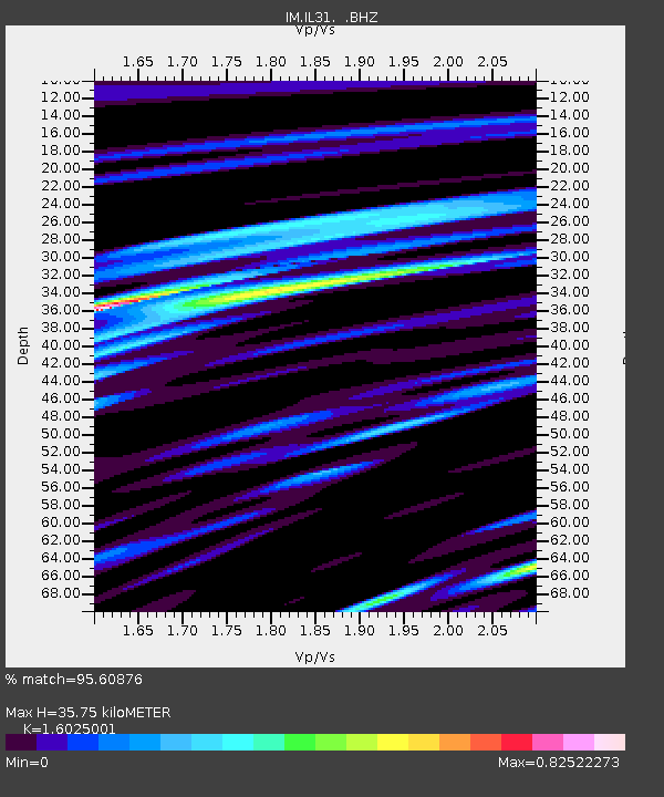
| Estimated Moho Depth: |
35.75 km |
| Estimated Crust Vp/Vs: |
1.60 |
| Assumed Crust Vp: |
6.566 km/s |
| Estimated Crust Vs: |
4.097 km/s |
| Estimated Crust Poisson's Ratio: |
0.18 |
|
| Radial Match: |
95.60876 % |
| Radial Bump: |
400 |
| Transverse Match: |
85.39745 % |
| Transverse Bump: |
400 |
| SOD ConfigId: |
512894 |
| Insert Time: |
2013-09-14 17:21:07.607 +0000 |
| GWidth: |
2.5 |
| Max Bumps: |
400 |
| Tol: |
0.001 |
|

Signal To Noise
| Channel | StoN | STA | LTA |
| IM:IL31: :BHZ:20130524T05:49:44.575001Z | 865.2883 | 8.779407E-6 | 1.0146221E-8 |
| IM:IL31: :BHN:20130524T05:49:44.575001Z | 484.50226 | 2.4695755E-6 | 5.097139E-9 |
| IM:IL31: :BHE:20130524T05:49:44.575001Z | 464.31442 | 3.995484E-6 | 8.605126E-9 |
| Arrivals |
| Ps | 3.6 SECOND |
| PpPs | 13 SECOND |
| PsPs/PpSs | 17 SECOND |


