You are here: Home > Network List > IU - Global Seismograph Network (GSN - IRIS/USGS) Stations List
> Station ANMO Albuquerque, New Mexico, USA > Earthquake Result Viewer
ANMO Albuquerque, New Mexico, USA - Earthquake Result Viewer

| Earthquake location: |
Sea Of Okhotsk |
| Earthquake latitude/longitude: |
54.9/153.2 |
| Earthquake time(UTC): |
2013/05/24 (144) 05:44:48 GMT |
| Earthquake Depth: |
598 km |
| Earthquake Magnitude: |
8.4 MW, 7.5 MB, 8.3 MW |
| Earthquake Catalog/Contributor: |
NEIC PDE/NEIC PDE-W |
|
| Network: |
IU Global Seismograph Network (GSN - IRIS/USGS) |
| Station: |
ANMO Albuquerque, New Mexico, USA |
| Lat/Lon: |
34.95 N/106.46 W |
| Elevation: |
1820 m |
|
| Distance: |
67.6 deg |
| Az: |
60.915 deg |
| Baz: |
322.08 deg |
| Ray Param: |
0.05466618 |
| Estimated Moho Depth: |
11.25 km |
| Estimated Crust Vp/Vs: |
1.70 |
| Assumed Crust Vp: |
6.502 km/s |
| Estimated Crust Vs: |
3.824 km/s |
| Estimated Crust Poisson's Ratio: |
0.24 |
|
| Radial Match: |
98.70149 % |
| Radial Bump: |
331 |
| Transverse Match: |
96.07914 % |
| Transverse Bump: |
400 |
| SOD ConfigId: |
512894 |
| Insert Time: |
2013-09-14 17:21:21.892 +0000 |
| GWidth: |
2.5 |
| Max Bumps: |
400 |
| Tol: |
0.001 |
|
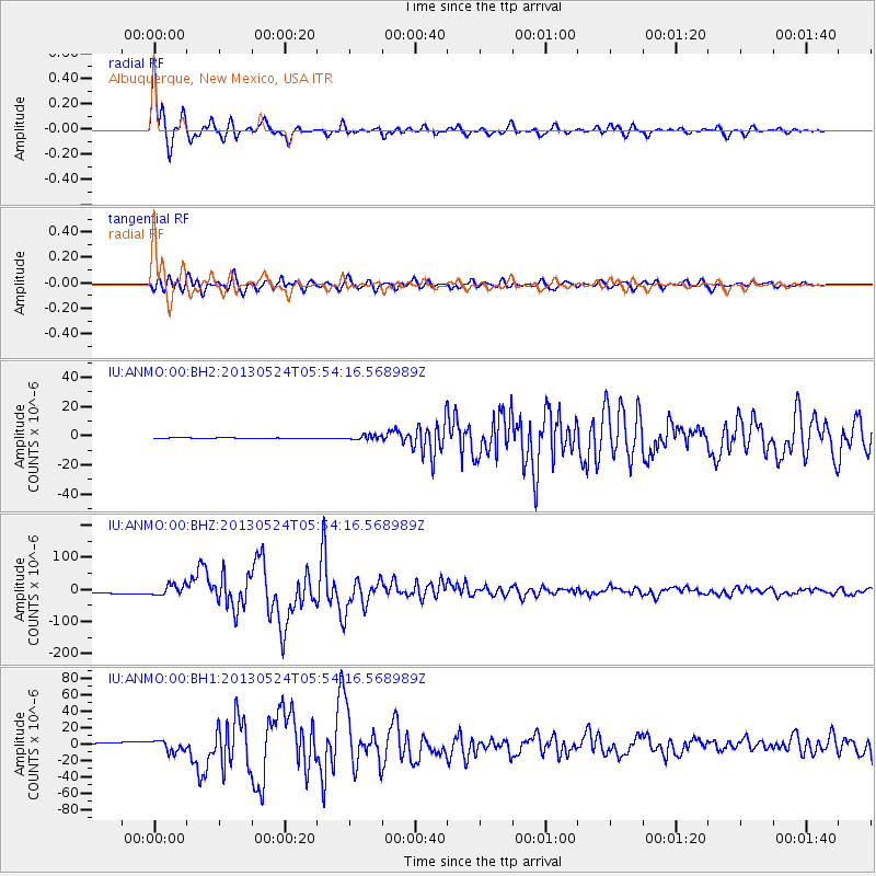
Signal To Noise
| Channel | StoN | STA | LTA |
| IU:ANMO:00:BHZ:20130524T05:54:16.568989Z | 6.73664 | 1.6628086E-5 | 2.4683054E-6 |
| IU:ANMO:00:BH1:20130524T05:54:16.568989Z | 6.091789 | 6.996806E-6 | 1.1485635E-6 |
| IU:ANMO:00:BH2:20130524T05:54:16.568989Z | 7.0048 | 1.4837703E-6 | 2.1182194E-7 |
| Arrivals |
| Ps | 1.3 SECOND |
| PpPs | 4.5 SECOND |
| PsPs/PpSs | 5.8 SECOND |


