You are here: Home > Network List > IU - Global Seismograph Network (GSN - IRIS/USGS) Stations List
> Station CTAO Charters Towers, Australia > Earthquake Result Viewer
CTAO Charters Towers, Australia - Earthquake Result Viewer
| Earthquake location: |
Sea Of Okhotsk |
| Earthquake latitude/longitude: |
54.9/153.2 |
| Earthquake time(UTC): |
2013/05/24 (144) 05:44:48 GMT |
| Earthquake Depth: |
598 km |
| Earthquake Magnitude: |
8.4 MW, 7.5 MB, 8.3 MW |
| Earthquake Catalog/Contributor: |
NEIC PDE/NEIC PDE-W |
|
| Network: |
IU Global Seismograph Network (GSN - IRIS/USGS) |
| Station: |
CTAO Charters Towers, Australia |
| Lat/Lon: |
20.09 S/146.25 E |
| Elevation: |
357 m |
|
| Distance: |
74.9 deg |
| Az: |
186.781 deg |
| Baz: |
4.162 deg |
| Ray Param: |
0.050058782 |
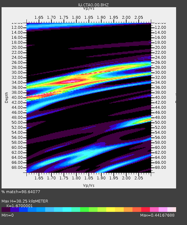
| Estimated Moho Depth: |
38.25 km |
| Estimated Crust Vp/Vs: |
1.67 |
| Assumed Crust Vp: |
6.522 km/s |
| Estimated Crust Vs: |
3.905 km/s |
| Estimated Crust Poisson's Ratio: |
0.22 |
|
| Radial Match: |
98.64077 % |
| Radial Bump: |
301 |
| Transverse Match: |
91.46985 % |
| Transverse Bump: |
400 |
| SOD ConfigId: |
512894 |
| Insert Time: |
2013-09-14 17:21:28.376 +0000 |
| GWidth: |
2.5 |
| Max Bumps: |
400 |
| Tol: |
0.001 |
|
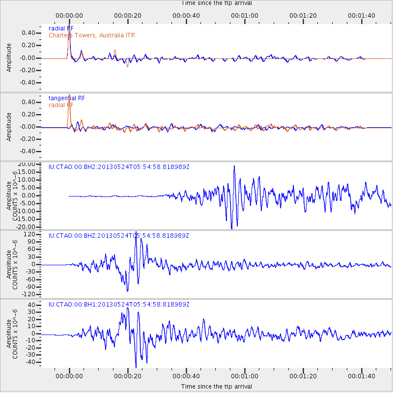
Signal To Noise
| Channel | StoN | STA | LTA |
| IU:CTAO:00:BHZ:20130524T05:54:58.818989Z | 12.425029 | 6.249569E-6 | 5.0298223E-7 |
| IU:CTAO:00:BH1:20130524T05:54:58.818989Z | 11.237914 | 2.4313997E-6 | 2.1635684E-7 |
| IU:CTAO:00:BH2:20130524T05:54:58.818989Z | 2.5887024 | 4.806475E-7 | 1.856712E-7 |
| Arrivals |
| Ps | 4.1 SECOND |
| PpPs | 15 SECOND |
| PsPs/PpSs | 19 SECOND |


