You are here: Home > Network List > IU - Global Seismograph Network (GSN - IRIS/USGS) Stations List
> Station RSSD Black Hills, South Dakota, USA > Earthquake Result Viewer
RSSD Black Hills, South Dakota, USA - Earthquake Result Viewer
| Earthquake location: |
Sea Of Okhotsk |
| Earthquake latitude/longitude: |
54.9/153.2 |
| Earthquake time(UTC): |
2013/05/24 (144) 05:44:48 GMT |
| Earthquake Depth: |
598 km |
| Earthquake Magnitude: |
8.4 MW, 7.5 MB, 8.3 MW |
| Earthquake Catalog/Contributor: |
NEIC PDE/NEIC PDE-W |
|
| Network: |
IU Global Seismograph Network (GSN - IRIS/USGS) |
| Station: |
RSSD Black Hills, South Dakota, USA |
| Lat/Lon: |
44.12 N/104.04 W |
| Elevation: |
2090 m |
|
| Distance: |
61.7 deg |
| Az: |
52.942 deg |
| Baz: |
320.198 deg |
| Ray Param: |
0.05838478 |
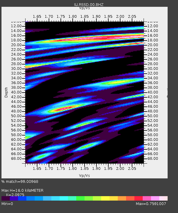
| Estimated Moho Depth: |
16.0 km |
| Estimated Crust Vp/Vs: |
2.10 |
| Assumed Crust Vp: |
6.242 km/s |
| Estimated Crust Vs: |
2.976 km/s |
| Estimated Crust Poisson's Ratio: |
0.35 |
|
| Radial Match: |
99.00968 % |
| Radial Bump: |
400 |
| Transverse Match: |
96.78575 % |
| Transverse Bump: |
400 |
| SOD ConfigId: |
512894 |
| Insert Time: |
2013-09-14 17:22:31.852 +0000 |
| GWidth: |
2.5 |
| Max Bumps: |
400 |
| Tol: |
0.001 |
|
Signal To Noise
| Channel | StoN | STA | LTA |
| IU:RSSD:00:BHZ:20130524T05:53:39.219014Z | 16.614216 | 4.144291E-5 | 2.4944247E-6 |
| IU:RSSD:00:BH1:20130524T05:53:39.219014Z | 18.638176 | 2.53078E-5 | 1.3578475E-6 |
| IU:RSSD:00:BH2:20130524T05:53:39.219014Z | 42.84323 | 1.1216379E-5 | 2.6180047E-7 |
| Arrivals |
| Ps | 2.9 SECOND |
| PpPs | 7.7 SECOND |
| PsPs/PpSs | 11 SECOND |


