You are here: Home > Network List > NI - North-East Italy Broadband Network Stations List
> Station ZOU2 Zouf Plan > Earthquake Result Viewer
ZOU2 Zouf Plan - Earthquake Result Viewer
| Earthquake location: |
Sea Of Okhotsk |
| Earthquake latitude/longitude: |
54.9/153.2 |
| Earthquake time(UTC): |
2013/05/24 (144) 05:44:48 GMT |
| Earthquake Depth: |
598 km |
| Earthquake Magnitude: |
8.4 MW, 7.5 MB, 8.3 MW |
| Earthquake Catalog/Contributor: |
NEIC PDE/NEIC PDE-W |
|
| Network: |
NI North-East Italy Broadband Network |
| Station: |
ZOU2 Zouf Plan |
| Lat/Lon: |
46.56 N/12.97 E |
| Elevation: |
1896 m |
|
| Distance: |
73.5 deg |
| Az: |
332.596 deg |
| Baz: |
22.664 deg |
| Ray Param: |
0.05097527 |
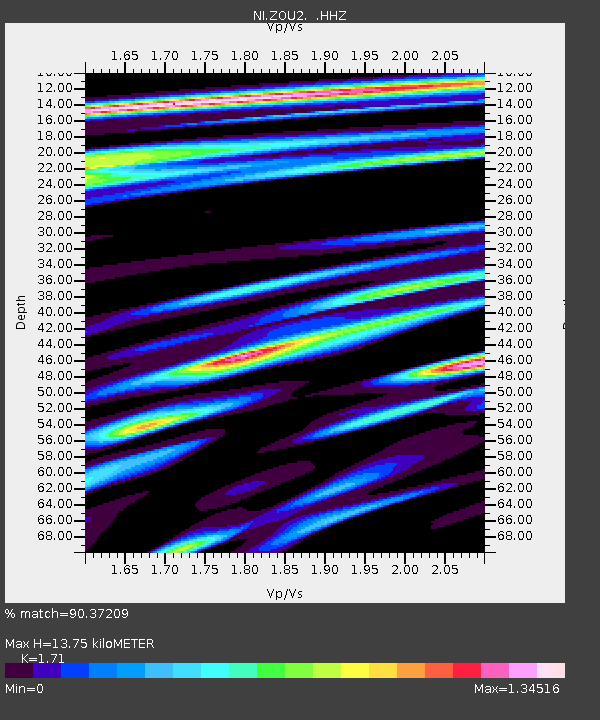
| Estimated Moho Depth: |
13.75 km |
| Estimated Crust Vp/Vs: |
1.71 |
| Assumed Crust Vp: |
6.35 km/s |
| Estimated Crust Vs: |
3.713 km/s |
| Estimated Crust Poisson's Ratio: |
0.24 |
|
| Radial Match: |
90.37209 % |
| Radial Bump: |
400 |
| Transverse Match: |
89.06617 % |
| Transverse Bump: |
400 |
| SOD ConfigId: |
512894 |
| Insert Time: |
2013-09-14 17:27:08.360 +0000 |
| GWidth: |
2.5 |
| Max Bumps: |
400 |
| Tol: |
0.001 |
|

Signal To Noise
| Channel | StoN | STA | LTA |
| NI:ZOU2: :HHZ:20130524T05:54:50.787983Z | 5.7100234 | 1.3873018E-5 | 2.4295905E-6 |
| NI:ZOU2: :HHN:20130524T05:54:50.787983Z | 2.0982249 | 3.6525778E-6 | 1.7407942E-6 |
| NI:ZOU2: :HHE:20130524T05:54:50.787983Z | 3.46058 | 1.579751E-6 | 4.5649892E-7 |
| Arrivals |
| Ps | 1.6 SECOND |
| PpPs | 5.7 SECOND |
| PsPs/PpSs | 7.3 SECOND |


