You are here: Home > Network List > CI - Caltech Regional Seismic Network Stations List
> Station SLA SLA, Trona, CA, USA > Earthquake Result Viewer
SLA SLA, Trona, CA, USA - Earthquake Result Viewer
| Earthquake location: |
Kermadec Islands Region |
| Earthquake latitude/longitude: |
-28.6/-177.6 |
| Earthquake time(UTC): |
1999/07/19 (200) 02:17:03 GMT |
| Earthquake Depth: |
39 km |
| Earthquake Magnitude: |
6.3 MB, 6.2 MS, 6.4 MW, 6.3 ME |
| Earthquake Catalog/Contributor: |
WHDF/NEIC |
|
| Network: |
CI Caltech Regional Seismic Network |
| Station: |
SLA SLA, Trona, CA, USA |
| Lat/Lon: |
35.89 N/117.28 W |
| Elevation: |
1174 m |
|
| Distance: |
85.7 deg |
| Az: |
45.032 deg |
| Baz: |
229.992 deg |
| Ray Param: |
0.044528432 |
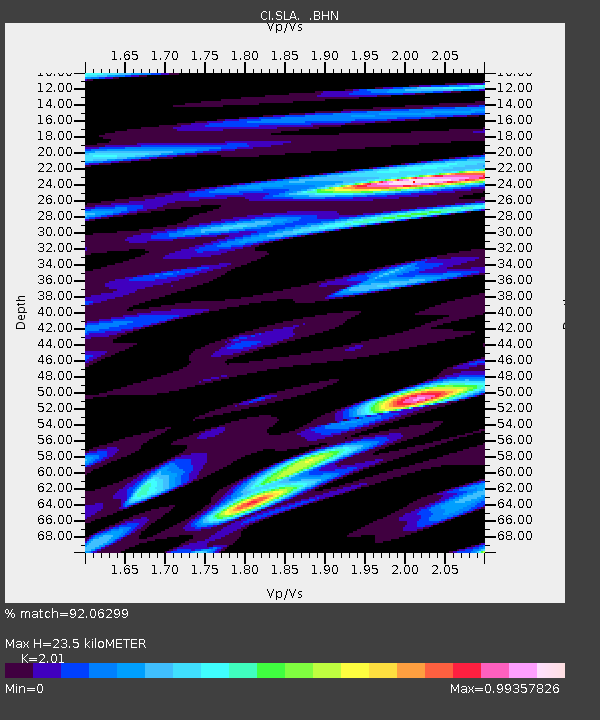
| Estimated Moho Depth: |
23.5 km |
| Estimated Crust Vp/Vs: |
2.01 |
| Assumed Crust Vp: |
6.276 km/s |
| Estimated Crust Vs: |
3.122 km/s |
| Estimated Crust Poisson's Ratio: |
0.34 |
|
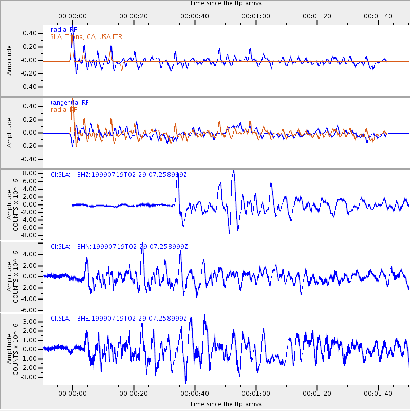
| Radial Match: |
92.06299 % |
| Radial Bump: |
400 |
| Transverse Match: |
73.55286 % |
| Transverse Bump: |
400 |
| SOD ConfigId: |
3787 |
| Insert Time: |
2010-02-25 20:33:27.965 +0000 |
| GWidth: |
2.5 |
| Max Bumps: |
400 |
| Tol: |
0.001 |
|
Signal To Noise
| Channel | StoN | STA | LTA |
| CI:SLA: :BHN:19990719T02:29:07.258999Z | 5.166549 | 1.0803373E-6 | 2.0910228E-7 |
| CI:SLA: :BHE:19990719T02:29:07.258999Z | 3.5719335 | 6.8247476E-7 | 1.9106592E-7 |
| CI:SLA: :BHZ:19990719T02:29:07.258999Z | 15.439428 | 2.8072195E-6 | 1.8182146E-7 |
| Arrivals |
| Ps | 3.9 SECOND |
| PpPs | 11 SECOND |
| PsPs/PpSs | 15 SECOND |


