You are here: Home > Network List > NM - Cooperative New Madrid Seismic Network Stations List
> Station PVMO UM Delta Research Portageville, MO > Earthquake Result Viewer
PVMO UM Delta Research Portageville, MO - Earthquake Result Viewer
| Earthquake location: |
Sea Of Okhotsk |
| Earthquake latitude/longitude: |
54.9/153.2 |
| Earthquake time(UTC): |
2013/05/24 (144) 05:44:48 GMT |
| Earthquake Depth: |
598 km |
| Earthquake Magnitude: |
8.4 MW, 7.5 MB, 8.3 MW |
| Earthquake Catalog/Contributor: |
NEIC PDE/NEIC PDE-W |
|
| Network: |
NM Cooperative New Madrid Seismic Network |
| Station: |
PVMO UM Delta Research Portageville, MO |
| Lat/Lon: |
36.41 N/89.70 W |
| Elevation: |
98 m |
|
| Distance: |
74.3 deg |
| Az: |
48.244 deg |
| Baz: |
327.706 deg |
| Ray Param: |
0.0504433 |
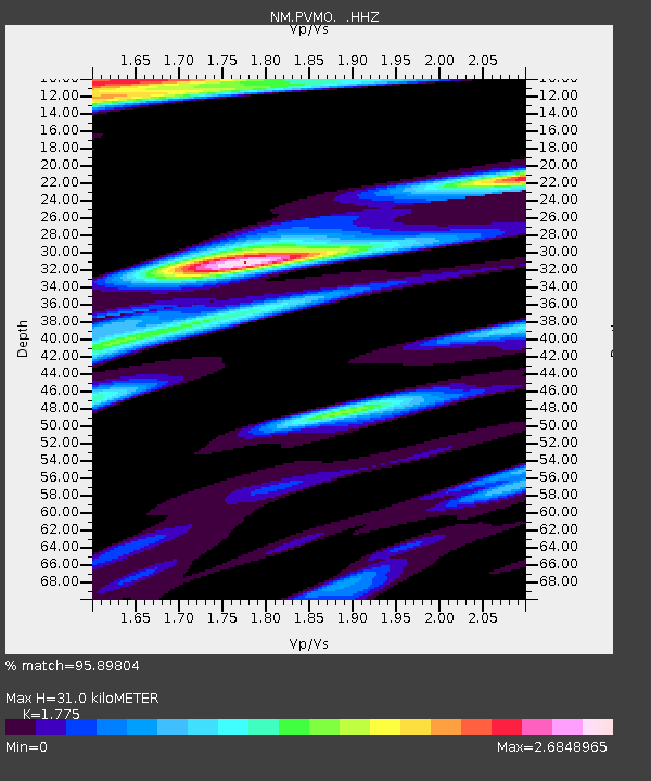
| Estimated Moho Depth: |
31.0 km |
| Estimated Crust Vp/Vs: |
1.77 |
| Assumed Crust Vp: |
6.444 km/s |
| Estimated Crust Vs: |
3.63 km/s |
| Estimated Crust Poisson's Ratio: |
0.27 |
|
| Radial Match: |
95.89804 % |
| Radial Bump: |
400 |
| Transverse Match: |
88.17524 % |
| Transverse Bump: |
400 |
| SOD ConfigId: |
512894 |
| Insert Time: |
2013-09-14 17:28:01.160 +0000 |
| GWidth: |
2.5 |
| Max Bumps: |
400 |
| Tol: |
0.001 |
|

Signal To Noise
| Channel | StoN | STA | LTA |
| NM:PVMO: :HHZ:20130524T05:54:55.459004Z | 27.967371 | 2.0535E-5 | 7.3424854E-7 |
| NM:PVMO: :HHN:20130524T05:54:55.459004Z | 15.514394 | 1.2393793E-5 | 7.9885774E-7 |
| NM:PVMO: :HHE:20130524T05:54:55.459004Z | 14.576954 | 1.0739912E-5 | 7.3677336E-7 |
| Arrivals |
| Ps | 3.8 SECOND |
| PpPs | 13 SECOND |
| PsPs/PpSs | 17 SECOND |


