You are here: Home > Network List > NM - Cooperative New Madrid Seismic Network Stations List
> Station UTMT Martin, TN > Earthquake Result Viewer
UTMT Martin, TN - Earthquake Result Viewer
| Earthquake location: |
Sea Of Okhotsk |
| Earthquake latitude/longitude: |
54.9/153.2 |
| Earthquake time(UTC): |
2013/05/24 (144) 05:44:48 GMT |
| Earthquake Depth: |
598 km |
| Earthquake Magnitude: |
8.4 MW, 7.5 MB, 8.3 MW |
| Earthquake Catalog/Contributor: |
NEIC PDE/NEIC PDE-W |
|
| Network: |
NM Cooperative New Madrid Seismic Network |
| Station: |
UTMT Martin, TN |
| Lat/Lon: |
36.35 N/88.86 W |
| Elevation: |
110 m |
|
| Distance: |
74.7 deg |
| Az: |
47.686 deg |
| Baz: |
328.051 deg |
| Ray Param: |
0.050176505 |
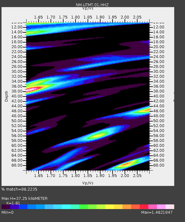
| Estimated Moho Depth: |
37.25 km |
| Estimated Crust Vp/Vs: |
1.61 |
| Assumed Crust Vp: |
6.444 km/s |
| Estimated Crust Vs: |
4.002 km/s |
| Estimated Crust Poisson's Ratio: |
0.19 |
|
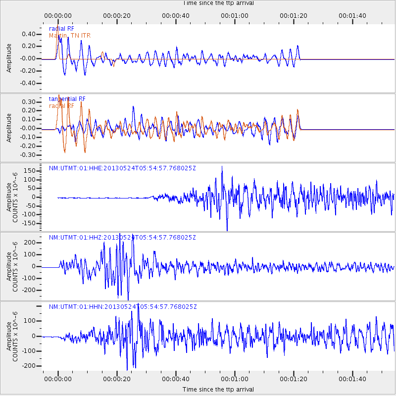
| Radial Match: |
86.2235 % |
| Radial Bump: |
400 |
| Transverse Match: |
86.47226 % |
| Transverse Bump: |
400 |
| SOD ConfigId: |
512894 |
| Insert Time: |
2013-09-14 17:28:12.392 +0000 |
| GWidth: |
2.5 |
| Max Bumps: |
400 |
| Tol: |
0.001 |
|
Signal To Noise
| Channel | StoN | STA | LTA |
| NM:UTMT:01:HHZ:20130524T05:54:57.768025Z | 59.410828 | 2.7240429E-5 | 4.585095E-7 |
| NM:UTMT:01:HHN:20130524T05:54:57.768025Z | 27.041586 | 1.1595655E-5 | 4.2880828E-7 |
| NM:UTMT:01:HHE:20130524T05:54:57.768025Z | 11.607497 | 5.7909338E-6 | 4.98896E-7 |
| Arrivals |
| Ps | 3.6 SECOND |
| PpPs | 15 SECOND |
| PsPs/PpSs | 18 SECOND |


