You are here: Home > Network List > NN - Western Great Basin/Eastern Sierra Nevada Stations List
> Station VCN Virginia City, Nevada gps > Earthquake Result Viewer
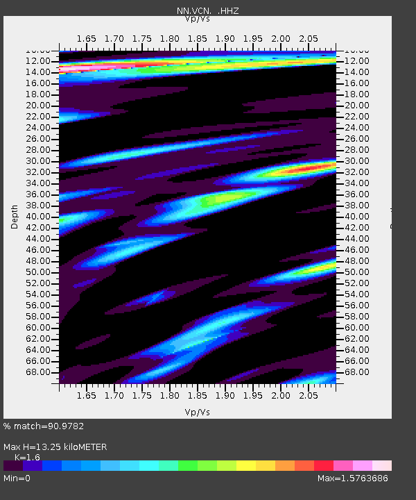
VCN Virginia City, Nevada gps - Earthquake Result Viewer
| Earthquake location: |
Sea Of Okhotsk |
| Earthquake latitude/longitude: |
54.9/153.2 |
| Earthquake time(UTC): |
2013/05/24 (144) 05:44:48 GMT |
| Earthquake Depth: |
598 km |
| Earthquake Magnitude: |
8.4 MW, 7.5 MB, 8.3 MW |
| Earthquake Catalog/Contributor: |
NEIC PDE/NEIC PDE-W |
|
| Network: |
NN Western Great Basin/Eastern Sierra Nevada |
| Station: |
VCN Virginia City, Nevada gps |
| Lat/Lon: |
39.30 N/119.65 W |
| Elevation: |
1928 m |
|
| Distance: |
57.5 deg |
| Az: |
66.768 deg |
| Baz: |
316.833 deg |
| Ray Param: |
0.060943857 |
| Estimated Moho Depth: |
13.25 km |
| Estimated Crust Vp/Vs: |
1.60 |
| Assumed Crust Vp: |
6.279 km/s |
| Estimated Crust Vs: |
3.924 km/s |
| Estimated Crust Poisson's Ratio: |
0.18 |
|
| Radial Match: |
90.9782 % |
| Radial Bump: |
400 |
| Transverse Match: |
84.23357 % |
| Transverse Bump: |
400 |
| SOD ConfigId: |
512894 |
| Insert Time: |
2013-09-14 17:28:50.821 +0000 |
| GWidth: |
2.5 |
| Max Bumps: |
400 |
| Tol: |
0.001 |
|

Signal To Noise
| Channel | StoN | STA | LTA |
| NN:VCN: :HHZ:20130524T05:53:11.585011Z | 10.394798 | 2.6947828E-5 | 2.592434E-6 |
| NN:VCN: :HHN:20130524T05:53:11.585011Z | 9.477159 | 8.9304685E-6 | 9.4231495E-7 |
| NN:VCN: :HHE:20130524T05:53:11.585011Z | 13.011754 | 1.3283672E-5 | 1.0208979E-6 |
| Arrivals |
| Ps | 1.3 SECOND |
| PpPs | 5.2 SECOND |
| PsPs/PpSs | 6.6 SECOND |


