You are here: Home > Network List > PE - Penn State Network Stations List
> Station PAGS PA Geological Survey > Earthquake Result Viewer
PAGS PA Geological Survey - Earthquake Result Viewer
| Earthquake location: |
Sea Of Okhotsk |
| Earthquake latitude/longitude: |
54.9/153.2 |
| Earthquake time(UTC): |
2013/05/24 (144) 05:44:48 GMT |
| Earthquake Depth: |
598 km |
| Earthquake Magnitude: |
8.4 MW, 7.5 MB, 8.3 MW |
| Earthquake Catalog/Contributor: |
NEIC PDE/NEIC PDE-W |
|
| Network: |
PE Penn State Network |
| Station: |
PAGS PA Geological Survey |
| Lat/Lon: |
40.23 N/76.72 W |
| Elevation: |
120 m |
|
| Distance: |
76.1 deg |
| Az: |
37.137 deg |
| Baz: |
332.9 deg |
| Ray Param: |
0.04929964 |
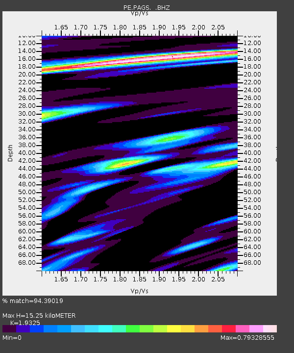
| Estimated Moho Depth: |
15.25 km |
| Estimated Crust Vp/Vs: |
1.93 |
| Assumed Crust Vp: |
6.121 km/s |
| Estimated Crust Vs: |
3.167 km/s |
| Estimated Crust Poisson's Ratio: |
0.32 |
|
| Radial Match: |
94.39019 % |
| Radial Bump: |
400 |
| Transverse Match: |
90.119606 % |
| Transverse Bump: |
400 |
| SOD ConfigId: |
512894 |
| Insert Time: |
2013-09-14 17:29:49.977 +0000 |
| GWidth: |
2.5 |
| Max Bumps: |
400 |
| Tol: |
0.001 |
|
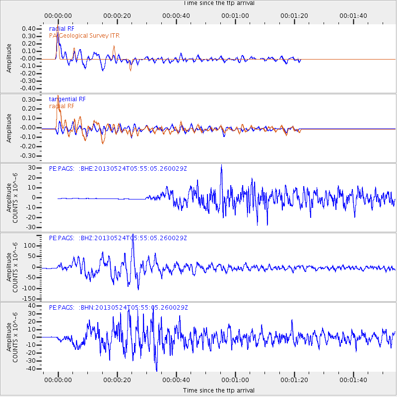
Signal To Noise
| Channel | StoN | STA | LTA |
| PE:PAGS: :BHZ:20130524T05:55:05.260029Z | 12.941974 | 9.250978E-6 | 7.148043E-7 |
| PE:PAGS: :BHN:20130524T05:55:05.260029Z | 7.416496 | 2.321088E-6 | 3.129629E-7 |
| PE:PAGS: :BHE:20130524T05:55:05.260029Z | 6.1476283 | 1.3124411E-6 | 2.134874E-7 |
| Arrivals |
| Ps | 2.4 SECOND |
| PpPs | 7.1 SECOND |
| PsPs/PpSs | 9.5 SECOND |


