You are here: Home > Network List > PO - Portable Observatories for Lithospheric Analysis and Research Investigating Seis Stations List
> Station BMRO Maryville Lake, ON, CANADA.A > Earthquake Result Viewer
BMRO Maryville Lake, ON, CANADA.A - Earthquake Result Viewer
| Earthquake location: |
Sea Of Okhotsk |
| Earthquake latitude/longitude: |
54.9/153.2 |
| Earthquake time(UTC): |
2013/05/24 (144) 05:44:48 GMT |
| Earthquake Depth: |
598 km |
| Earthquake Magnitude: |
8.4 MW, 7.5 MB, 8.3 MW |
| Earthquake Catalog/Contributor: |
NEIC PDE/NEIC PDE-W |
|
| Network: |
PO Portable Observatories for Lithospheric Analysis and Research Investigating Seis |
| Station: |
BMRO Maryville Lake, ON, CANADA.A |
| Lat/Lon: |
44.60 N/81.22 W |
| Elevation: |
217 m |
|
| Distance: |
70.7 deg |
| Az: |
38.019 deg |
| Baz: |
330.129 deg |
| Ray Param: |
0.05277139 |
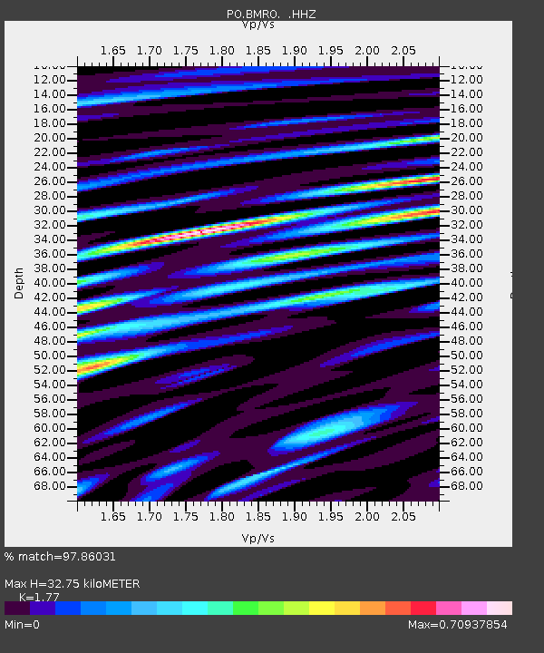
| Estimated Moho Depth: |
32.75 km |
| Estimated Crust Vp/Vs: |
1.77 |
| Assumed Crust Vp: |
6.53 km/s |
| Estimated Crust Vs: |
3.69 km/s |
| Estimated Crust Poisson's Ratio: |
0.27 |
|
| Radial Match: |
97.86031 % |
| Radial Bump: |
400 |
| Transverse Match: |
87.24428 % |
| Transverse Bump: |
400 |
| SOD ConfigId: |
512894 |
| Insert Time: |
2013-09-14 17:30:37.814 +0000 |
| GWidth: |
2.5 |
| Max Bumps: |
400 |
| Tol: |
0.001 |
|

Signal To Noise
| Channel | StoN | STA | LTA |
| PO:BMRO: :HHZ:20130524T05:54:34.570027Z | 21.760004 | 2.0792097E-5 | 9.55519E-7 |
| PO:BMRO: :HHN:20130524T05:54:34.570027Z | 16.293299 | 6.6171956E-6 | 4.0612986E-7 |
| PO:BMRO: :HHE:20130524T05:54:34.570027Z | 15.472342 | 4.832667E-6 | 3.123423E-7 |
| Arrivals |
| Ps | 4.0 SECOND |
| PpPs | 13 SECOND |
| PsPs/PpSs | 17 SECOND |


