You are here: Home > Network List > PT - Pacific Tsunami Warning Seismic System Stations List
> Station KHLH Kahului, Maui, Hawaii > Earthquake Result Viewer
KHLH Kahului, Maui, Hawaii - Earthquake Result Viewer
| Earthquake location: |
Sea Of Okhotsk |
| Earthquake latitude/longitude: |
54.9/153.2 |
| Earthquake time(UTC): |
2013/05/24 (144) 05:44:48 GMT |
| Earthquake Depth: |
598 km |
| Earthquake Magnitude: |
8.4 MW, 7.5 MB, 8.3 MW |
| Earthquake Catalog/Contributor: |
NEIC PDE/NEIC PDE-W |
|
| Network: |
PT Pacific Tsunami Warning Seismic System |
| Station: |
KHLH Kahului, Maui, Hawaii |
| Lat/Lon: |
20.90 N/156.43 W |
| Elevation: |
14 m |
|
| Distance: |
50.6 deg |
| Az: |
111.398 deg |
| Baz: |
324.882 deg |
| Ray Param: |
0.0651496 |
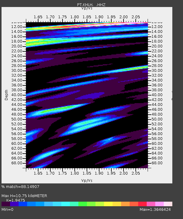
| Estimated Moho Depth: |
10.75 km |
| Estimated Crust Vp/Vs: |
1.95 |
| Assumed Crust Vp: |
5.265 km/s |
| Estimated Crust Vs: |
2.704 km/s |
| Estimated Crust Poisson's Ratio: |
0.32 |
|
| Radial Match: |
88.14907 % |
| Radial Bump: |
400 |
| Transverse Match: |
77.09745 % |
| Transverse Bump: |
385 |
| SOD ConfigId: |
512894 |
| Insert Time: |
2013-09-14 17:32:34.361 +0000 |
| GWidth: |
2.5 |
| Max Bumps: |
400 |
| Tol: |
0.001 |
|

Signal To Noise
| Channel | StoN | STA | LTA |
| PT:KHLH: :HHZ:20130524T05:52:23.680012Z | 17.222723 | 8.319698E-5 | 4.830652E-6 |
| PT:KHLH: :HHN:20130524T05:52:23.680012Z | 7.3264117 | 1.2322003E-5 | 1.6818606E-6 |
| PT:KHLH: :HHE:20130524T05:52:23.680012Z | 10.3223095 | 3.308693E-5 | 3.2053806E-6 |
| Arrivals |
| Ps | 2.0 SECOND |
| PpPs | 5.8 SECOND |
| PsPs/PpSs | 7.8 SECOND |


