You are here: Home > Network List > TA - USArray Transportable Network (new EarthScope stations) Stations List
> Station P56A Dayton Farm, Ripley, WV, USA > Earthquake Result Viewer
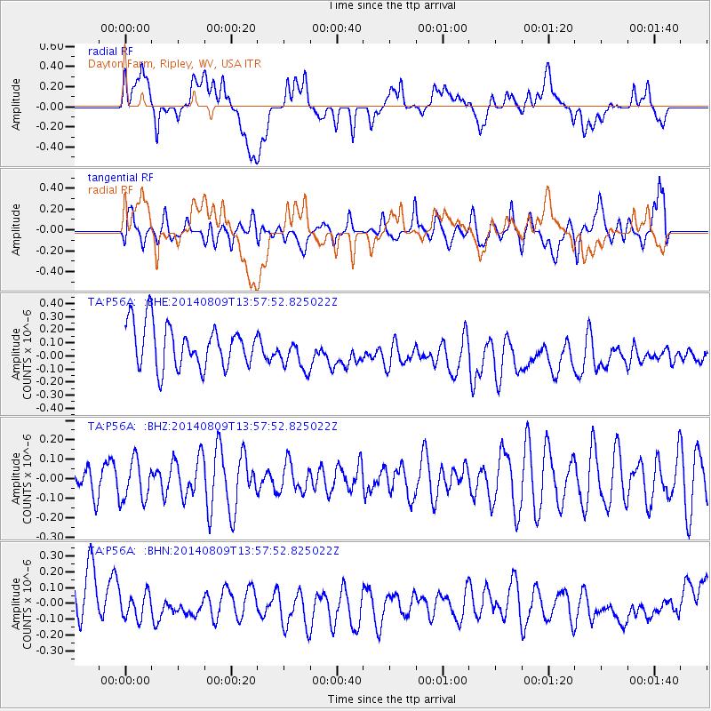
P56A Dayton Farm, Ripley, WV, USA - Earthquake Result Viewer
*The percent match for this event was below the threshold and hence no stack was calculated.
| Earthquake location: |
Central Italy |
| Earthquake latitude/longitude: |
43.5/11.0 |
| Earthquake time(UTC): |
2014/08/09 (221) 13:47:49 GMT |
| Earthquake Depth: |
9.9 km |
| Earthquake Magnitude: |
3.4 Mw, 3.4 ML |
| Earthquake Catalog/Contributor: |
ISC/ISC |
|
| Network: |
TA USArray Transportable Network (new EarthScope stations) |
| Station: |
P56A Dayton Farm, Ripley, WV, USA |
| Lat/Lon: |
39.50 N/78.84 W |
| Elevation: |
249 m |
|
| Distance: |
64.1 deg |
| Az: |
300.713 deg |
| Baz: |
53.915 deg |
| Ray Param: |
$rayparam |
*The percent match for this event was below the threshold and hence was not used in the summary stack. |
|
| Radial Match: |
19.75613 % |
| Radial Bump: |
400 |
| Transverse Match: |
38.1075 % |
| Transverse Bump: |
400 |
| SOD ConfigId: |
3390531 |
| Insert Time: |
2019-04-13 06:38:29.433 +0000 |
| GWidth: |
2.5 |
| Max Bumps: |
400 |
| Tol: |
0.001 |
|
Signal To Noise
| Channel | StoN | STA | LTA |
| TA:P56A: :BHZ:20140809T13:57:52.825022Z | 1.330258 | 1.0320113E-7 | 7.7579784E-8 |
| TA:P56A: :BHN:20140809T13:57:52.825022Z | 1.09181 | 1.4642926E-7 | 1.3411608E-7 |
| TA:P56A: :BHE:20140809T13:57:52.825022Z | 0.8308406 | 1.3580456E-7 | 1.634544E-7 |
| Arrivals |
| Ps | |
| PpPs | |
| PsPs/PpSs | |


