You are here: Home > Network List > TA - USArray Transportable Network (new EarthScope stations) Stations List
> Station 058A Arcadia, FL, USA > Earthquake Result Viewer
058A Arcadia, FL, USA - Earthquake Result Viewer
| Earthquake location: |
Sea Of Okhotsk |
| Earthquake latitude/longitude: |
54.9/153.2 |
| Earthquake time(UTC): |
2013/05/24 (144) 05:44:48 GMT |
| Earthquake Depth: |
598 km |
| Earthquake Magnitude: |
8.4 MW, 7.5 MB, 8.3 MW |
| Earthquake Catalog/Contributor: |
NEIC PDE/NEIC PDE-W |
|
| Network: |
TA USArray Transportable Network (new EarthScope stations) |
| Station: |
058A Arcadia, FL, USA |
| Lat/Lon: |
27.06 N/81.80 W |
| Elevation: |
15 m |
|
| Distance: |
85.8 deg |
| Az: |
47.117 deg |
| Baz: |
331.662 deg |
| Ray Param: |
0.042798165 |
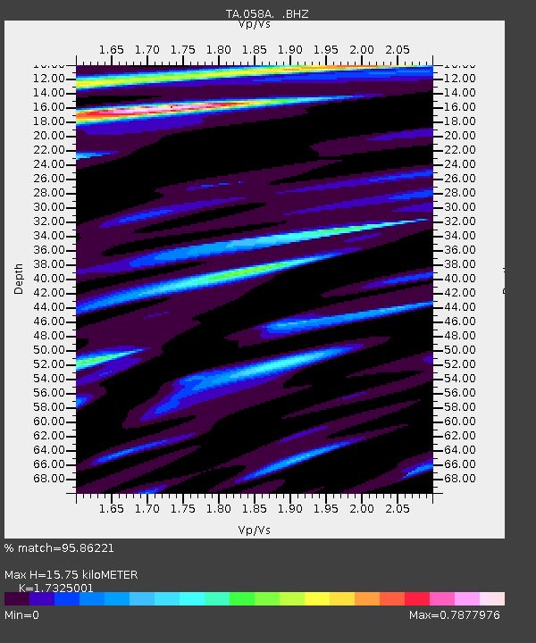
| Estimated Moho Depth: |
15.75 km |
| Estimated Crust Vp/Vs: |
1.73 |
| Assumed Crust Vp: |
6.347 km/s |
| Estimated Crust Vs: |
3.664 km/s |
| Estimated Crust Poisson's Ratio: |
0.25 |
|
| Radial Match: |
95.86221 % |
| Radial Bump: |
400 |
| Transverse Match: |
94.34461 % |
| Transverse Bump: |
400 |
| SOD ConfigId: |
512894 |
| Insert Time: |
2013-09-14 17:33:33.142 +0000 |
| GWidth: |
2.5 |
| Max Bumps: |
400 |
| Tol: |
0.001 |
|
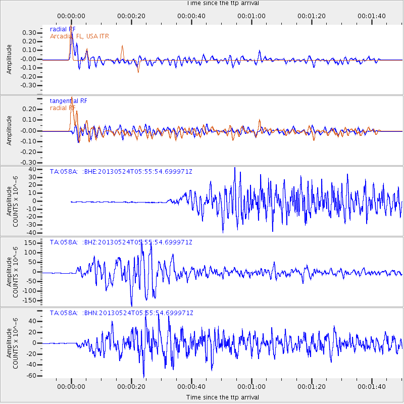
Signal To Noise
| Channel | StoN | STA | LTA |
| TA:058A: :BHZ:20130524T05:55:54.699971Z | 15.842896 | 1.2611304E-5 | 7.9602256E-7 |
| TA:058A: :BHN:20130524T05:55:54.699971Z | 8.835188 | 3.1766444E-6 | 3.5954463E-7 |
| TA:058A: :BHE:20130524T05:55:54.699971Z | 4.6783 | 1.3691601E-6 | 2.926619E-7 |
| Arrivals |
| Ps | 1.9 SECOND |
| PpPs | 6.6 SECOND |
| PsPs/PpSs | 8.5 SECOND |


