You are here: Home > Network List > TA - USArray Transportable Network (new EarthScope stations) Stations List
> Station 060Z West Palm Beach, FL, USA > Earthquake Result Viewer
060Z West Palm Beach, FL, USA - Earthquake Result Viewer
| Earthquake location: |
Sea Of Okhotsk |
| Earthquake latitude/longitude: |
54.9/153.2 |
| Earthquake time(UTC): |
2013/05/24 (144) 05:44:48 GMT |
| Earthquake Depth: |
598 km |
| Earthquake Magnitude: |
8.4 MW, 7.5 MB, 8.3 MW |
| Earthquake Catalog/Contributor: |
NEIC PDE/NEIC PDE-W |
|
| Network: |
TA USArray Transportable Network (new EarthScope stations) |
| Station: |
060Z West Palm Beach, FL, USA |
| Lat/Lon: |
26.41 N/80.56 W |
| Elevation: |
9.0 m |
|
| Distance: |
86.9 deg |
| Az: |
46.436 deg |
| Baz: |
332.176 deg |
| Ray Param: |
0.042024113 |
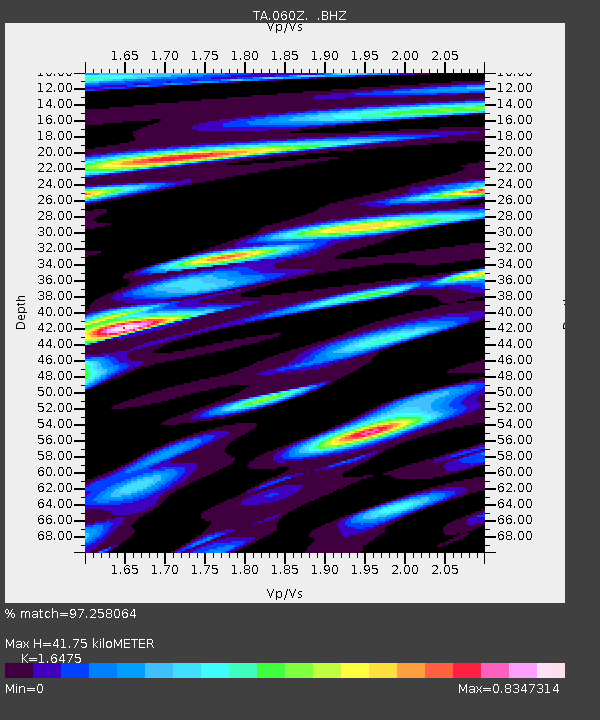
| Estimated Moho Depth: |
41.75 km |
| Estimated Crust Vp/Vs: |
1.65 |
| Assumed Crust Vp: |
6.347 km/s |
| Estimated Crust Vs: |
3.853 km/s |
| Estimated Crust Poisson's Ratio: |
0.21 |
|
| Radial Match: |
97.258064 % |
| Radial Bump: |
400 |
| Transverse Match: |
95.69512 % |
| Transverse Bump: |
400 |
| SOD ConfigId: |
512894 |
| Insert Time: |
2013-09-14 17:33:45.042 +0000 |
| GWidth: |
2.5 |
| Max Bumps: |
400 |
| Tol: |
0.001 |
|
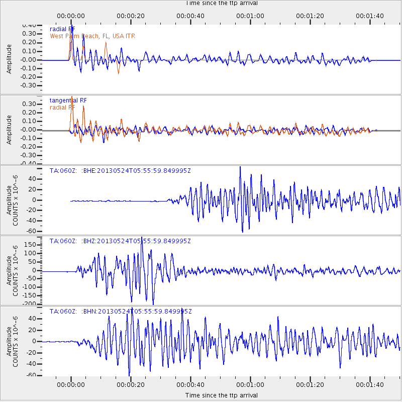
Signal To Noise
| Channel | StoN | STA | LTA |
| TA:060Z: :BHZ:20130524T05:55:59.849995Z | 19.172934 | 1.4317189E-5 | 7.467396E-7 |
| TA:060Z: :BHN:20130524T05:55:59.849995Z | 4.727323 | 2.467065E-6 | 5.218736E-7 |
| TA:060Z: :BHE:20130524T05:55:59.849995Z | 3.8517778 | 1.5607761E-6 | 4.052093E-7 |
| Arrivals |
| Ps | 4.4 SECOND |
| PpPs | 17 SECOND |
| PsPs/PpSs | 21 SECOND |


