You are here: Home > Network List > TA - USArray Transportable Network (new EarthScope stations) Stations List
> Station 109C Camp Elliot, Mirimar, CA, USA > Earthquake Result Viewer
109C Camp Elliot, Mirimar, CA, USA - Earthquake Result Viewer
| Earthquake location: |
Sea Of Okhotsk |
| Earthquake latitude/longitude: |
54.9/153.2 |
| Earthquake time(UTC): |
2013/05/24 (144) 05:44:48 GMT |
| Earthquake Depth: |
598 km |
| Earthquake Magnitude: |
8.4 MW, 7.5 MB, 8.3 MW |
| Earthquake Catalog/Contributor: |
NEIC PDE/NEIC PDE-W |
|
| Network: |
TA USArray Transportable Network (new EarthScope stations) |
| Station: |
109C Camp Elliot, Mirimar, CA, USA |
| Lat/Lon: |
32.89 N/117.11 W |
| Elevation: |
150 m |
|
| Distance: |
63.6 deg |
| Az: |
69.875 deg |
| Baz: |
319.857 deg |
| Ray Param: |
0.057155885 |
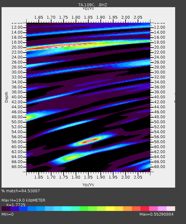
| Estimated Moho Depth: |
19.0 km |
| Estimated Crust Vp/Vs: |
1.77 |
| Assumed Crust Vp: |
6.264 km/s |
| Estimated Crust Vs: |
3.534 km/s |
| Estimated Crust Poisson's Ratio: |
0.27 |
|
| Radial Match: |
94.53887 % |
| Radial Bump: |
400 |
| Transverse Match: |
88.43888 % |
| Transverse Bump: |
400 |
| SOD ConfigId: |
512894 |
| Insert Time: |
2013-09-14 17:33:50.225 +0000 |
| GWidth: |
2.5 |
| Max Bumps: |
400 |
| Tol: |
0.001 |
|

Signal To Noise
| Channel | StoN | STA | LTA |
| TA:109C: :BHZ:20130524T05:53:51.818989Z | 8.308637 | 2.476915E-5 | 2.9811329E-6 |
| TA:109C: :BHN:20130524T05:53:51.818989Z | 7.8556848 | 9.185407E-6 | 1.1692688E-6 |
| TA:109C: :BHE:20130524T05:53:51.818989Z | 8.600868 | 8.710259E-6 | 1.0127186E-6 |
| Arrivals |
| Ps | 2.4 SECOND |
| PpPs | 8.1 SECOND |
| PsPs/PpSs | 11 SECOND |


