You are here: Home > Network List > TA - USArray Transportable Network (new EarthScope stations) Stations List
> Station 151A Opelika, AL, USA > Earthquake Result Viewer
151A Opelika, AL, USA - Earthquake Result Viewer
| Earthquake location: |
Sea Of Okhotsk |
| Earthquake latitude/longitude: |
54.9/153.2 |
| Earthquake time(UTC): |
2013/05/24 (144) 05:44:48 GMT |
| Earthquake Depth: |
598 km |
| Earthquake Magnitude: |
8.4 MW, 7.5 MB, 8.3 MW |
| Earthquake Catalog/Contributor: |
NEIC PDE/NEIC PDE-W |
|
| Network: |
TA USArray Transportable Network (new EarthScope stations) |
| Station: |
151A Opelika, AL, USA |
| Lat/Lon: |
32.53 N/85.33 W |
| Elevation: |
211 m |
|
| Distance: |
79.5 deg |
| Az: |
47.131 deg |
| Baz: |
329.92 deg |
| Ray Param: |
0.04705437 |
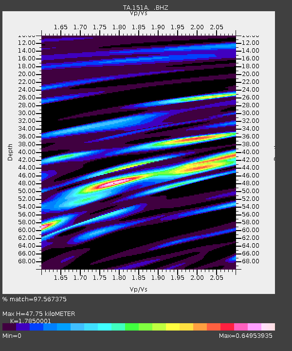
| Estimated Moho Depth: |
47.75 km |
| Estimated Crust Vp/Vs: |
1.79 |
| Assumed Crust Vp: |
6.719 km/s |
| Estimated Crust Vs: |
3.764 km/s |
| Estimated Crust Poisson's Ratio: |
0.27 |
|
| Radial Match: |
97.567375 % |
| Radial Bump: |
400 |
| Transverse Match: |
92.65311 % |
| Transverse Bump: |
400 |
| SOD ConfigId: |
512894 |
| Insert Time: |
2013-09-14 17:34:05.747 +0000 |
| GWidth: |
2.5 |
| Max Bumps: |
400 |
| Tol: |
0.001 |
|
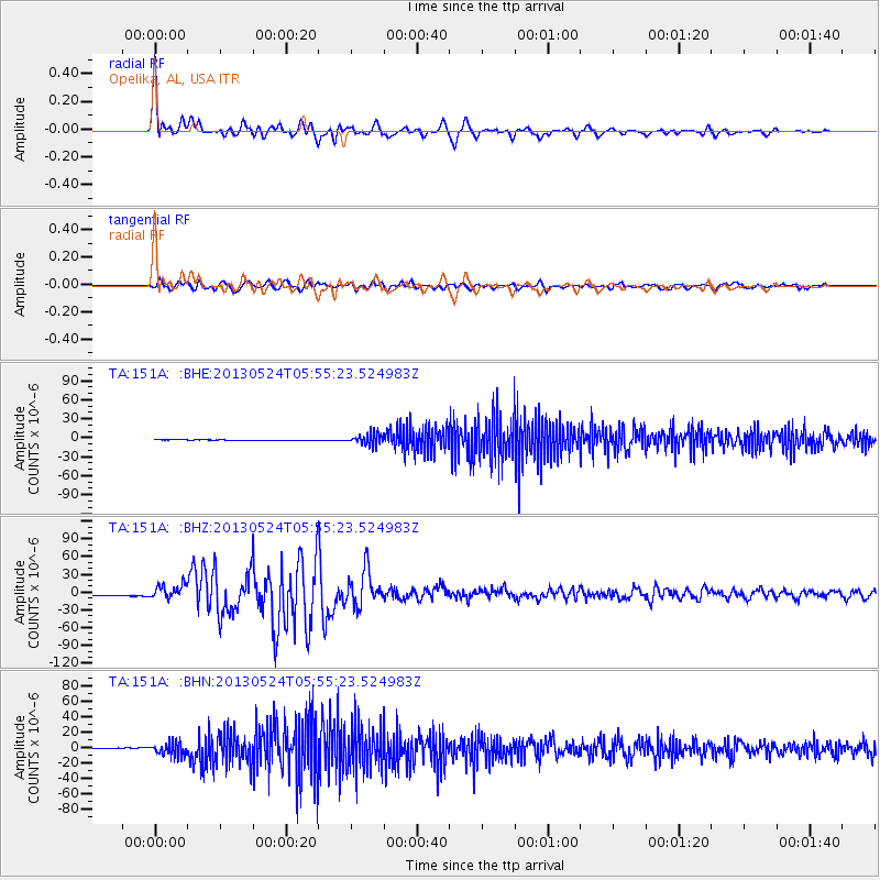
Signal To Noise
| Channel | StoN | STA | LTA |
| TA:151A: :BHZ:20130524T05:55:23.524983Z | 11.538407 | 1.2190428E-5 | 1.0565087E-6 |
| TA:151A: :BHN:20130524T05:55:23.524983Z | 18.927223 | 8.233741E-6 | 4.3502106E-7 |
| TA:151A: :BHE:20130524T05:55:23.524983Z | 28.284271 | 8.34584E-6 | 2.9507E-7 |
| Arrivals |
| Ps | 5.7 SECOND |
| PpPs | 19 SECOND |
| PsPs/PpSs | 25 SECOND |


