You are here: Home > Network List > TA - USArray Transportable Network (new EarthScope stations) Stations List
> Station 153A Fort Valley, GA, USA > Earthquake Result Viewer
153A Fort Valley, GA, USA - Earthquake Result Viewer
| Earthquake location: |
Sea Of Okhotsk |
| Earthquake latitude/longitude: |
54.9/153.2 |
| Earthquake time(UTC): |
2013/05/24 (144) 05:44:48 GMT |
| Earthquake Depth: |
598 km |
| Earthquake Magnitude: |
8.4 MW, 7.5 MB, 8.3 MW |
| Earthquake Catalog/Contributor: |
NEIC PDE/NEIC PDE-W |
|
| Network: |
TA USArray Transportable Network (new EarthScope stations) |
| Station: |
153A Fort Valley, GA, USA |
| Lat/Lon: |
32.66 N/83.83 W |
| Elevation: |
160 m |
|
| Distance: |
80.0 deg |
| Az: |
45.951 deg |
| Baz: |
330.512 deg |
| Ray Param: |
0.04671601 |
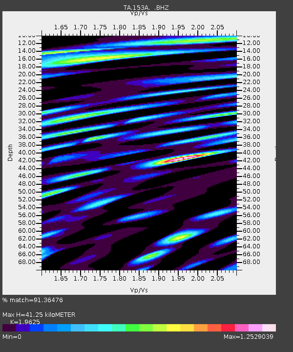
| Estimated Moho Depth: |
41.25 km |
| Estimated Crust Vp/Vs: |
1.96 |
| Assumed Crust Vp: |
6.565 km/s |
| Estimated Crust Vs: |
3.345 km/s |
| Estimated Crust Poisson's Ratio: |
0.32 |
|
| Radial Match: |
91.36476 % |
| Radial Bump: |
400 |
| Transverse Match: |
80.32054 % |
| Transverse Bump: |
400 |
| SOD ConfigId: |
512894 |
| Insert Time: |
2013-09-14 17:34:10.790 +0000 |
| GWidth: |
2.5 |
| Max Bumps: |
400 |
| Tol: |
0.001 |
|
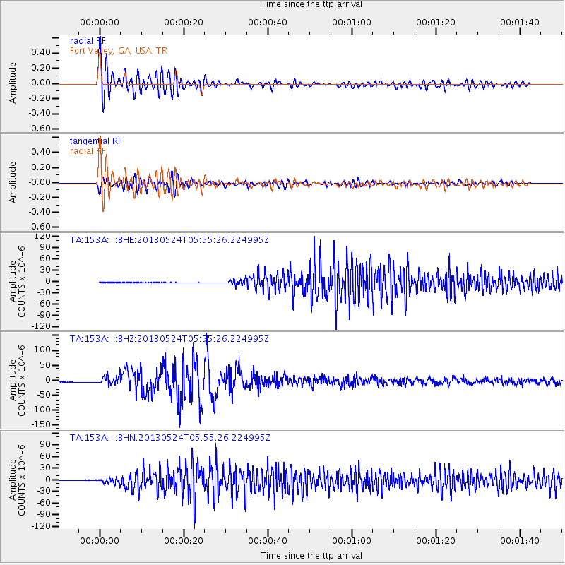
Signal To Noise
| Channel | StoN | STA | LTA |
| TA:153A: :BHZ:20130524T05:55:26.224995Z | 14.3649 | 1.4261502E-5 | 9.92802E-7 |
| TA:153A: :BHN:20130524T05:55:26.224995Z | 10.058214 | 5.6638405E-6 | 5.6310597E-7 |
| TA:153A: :BHE:20130524T05:55:26.224995Z | 15.213245 | 6.3376647E-6 | 4.165886E-7 |
| Arrivals |
| Ps | 6.2 SECOND |
| PpPs | 18 SECOND |
| PsPs/PpSs | 24 SECOND |


