You are here: Home > Network List > TA - USArray Transportable Network (new EarthScope stations) Stations List
> Station 252A Lumpkin, GA, USA > Earthquake Result Viewer
252A Lumpkin, GA, USA - Earthquake Result Viewer
| Earthquake location: |
Sea Of Okhotsk |
| Earthquake latitude/longitude: |
54.9/153.2 |
| Earthquake time(UTC): |
2013/05/24 (144) 05:44:48 GMT |
| Earthquake Depth: |
598 km |
| Earthquake Magnitude: |
8.4 MW, 7.5 MB, 8.3 MW |
| Earthquake Catalog/Contributor: |
NEIC PDE/NEIC PDE-W |
|
| Network: |
TA USArray Transportable Network (new EarthScope stations) |
| Station: |
252A Lumpkin, GA, USA |
| Lat/Lon: |
32.00 N/84.74 W |
| Elevation: |
142 m |
|
| Distance: |
80.2 deg |
| Az: |
46.959 deg |
| Baz: |
330.203 deg |
| Ray Param: |
0.04658576 |
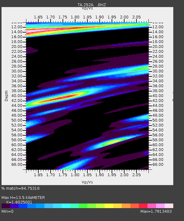
| Estimated Moho Depth: |
13.5 km |
| Estimated Crust Vp/Vs: |
1.60 |
| Assumed Crust Vp: |
6.347 km/s |
| Estimated Crust Vs: |
3.961 km/s |
| Estimated Crust Poisson's Ratio: |
0.18 |
|
| Radial Match: |
94.75318 % |
| Radial Bump: |
400 |
| Transverse Match: |
92.58206 % |
| Transverse Bump: |
400 |
| SOD ConfigId: |
512894 |
| Insert Time: |
2013-09-14 17:34:37.527 +0000 |
| GWidth: |
2.5 |
| Max Bumps: |
400 |
| Tol: |
0.001 |
|
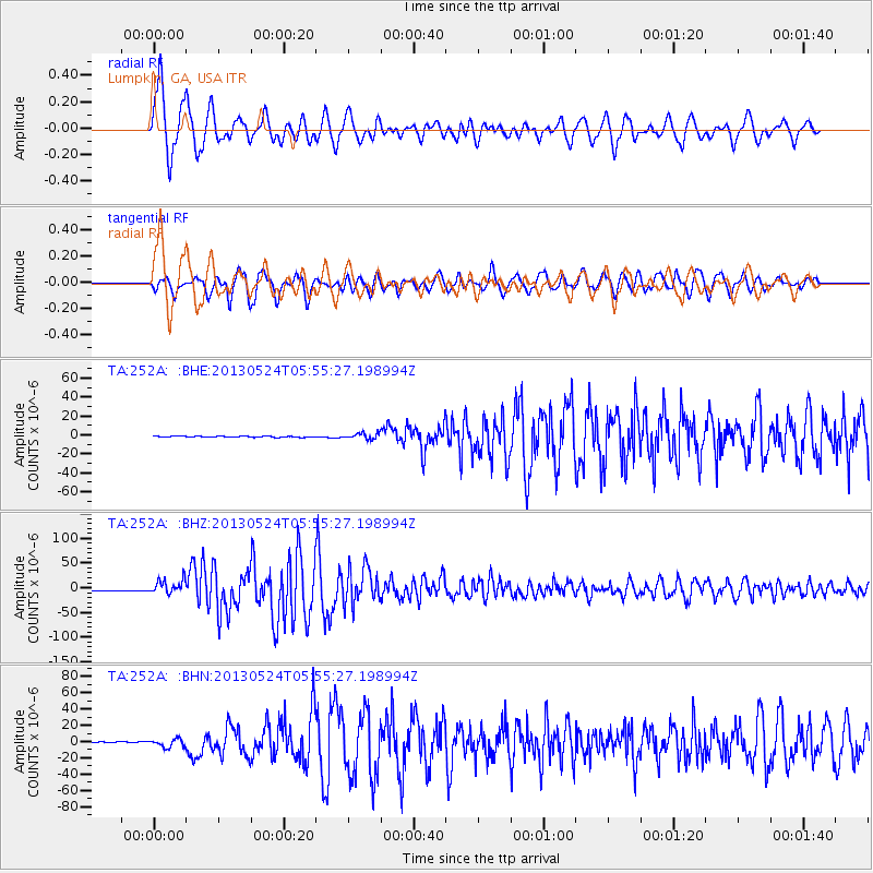
Signal To Noise
| Channel | StoN | STA | LTA |
| TA:252A: :BHZ:20130524T05:55:27.198994Z | 14.493088 | 1.4620986E-5 | 1.0088247E-6 |
| TA:252A: :BHN:20130524T05:55:27.198994Z | 11.150675 | 5.151131E-6 | 4.6195686E-7 |
| TA:252A: :BHE:20130524T05:55:27.198994Z | 5.716021 | 3.153862E-6 | 5.517583E-7 |
| Arrivals |
| Ps | 1.3 SECOND |
| PpPs | 5.4 SECOND |
| PsPs/PpSs | 6.7 SECOND |


