You are here: Home > Network List > TA - USArray Transportable Network (new EarthScope stations) Stations List
> Station 357A Townsend, GA, USA > Earthquake Result Viewer
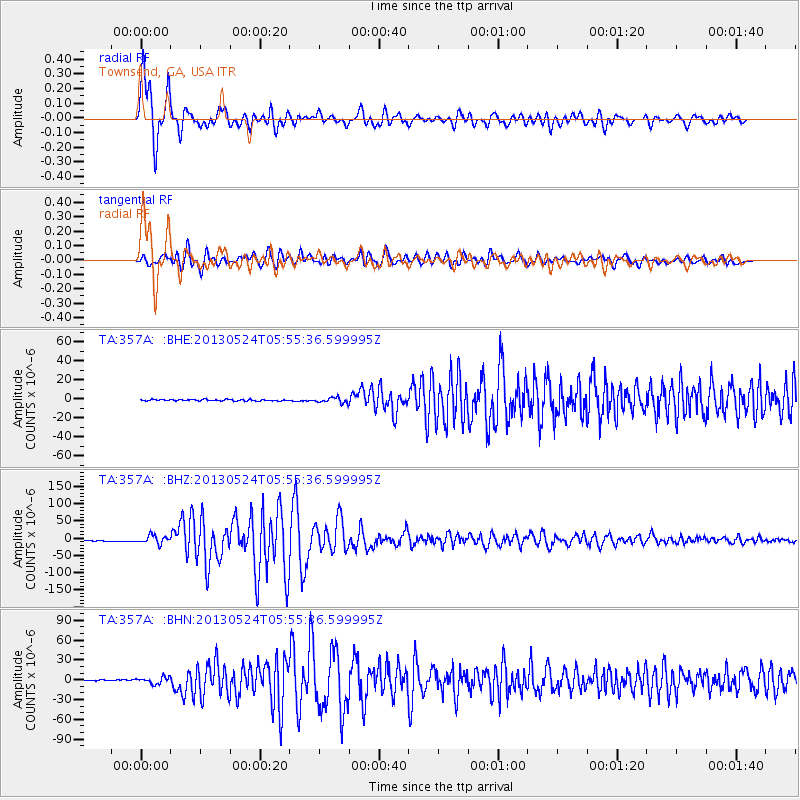
357A Townsend, GA, USA - Earthquake Result Viewer
| Earthquake location: |
Sea Of Okhotsk |
| Earthquake latitude/longitude: |
54.9/153.2 |
| Earthquake time(UTC): |
2013/05/24 (144) 05:44:48 GMT |
| Earthquake Depth: |
598 km |
| Earthquake Magnitude: |
8.4 MW, 7.5 MB, 8.3 MW |
| Earthquake Catalog/Contributor: |
NEIC PDE/NEIC PDE-W |
|
| Network: |
TA USArray Transportable Network (new EarthScope stations) |
| Station: |
357A Townsend, GA, USA |
| Lat/Lon: |
31.42 N/81.49 W |
| Elevation: |
7.0 m |
|
| Distance: |
82.1 deg |
| Az: |
44.79 deg |
| Baz: |
331.57 deg |
| Ray Param: |
0.045344364 |
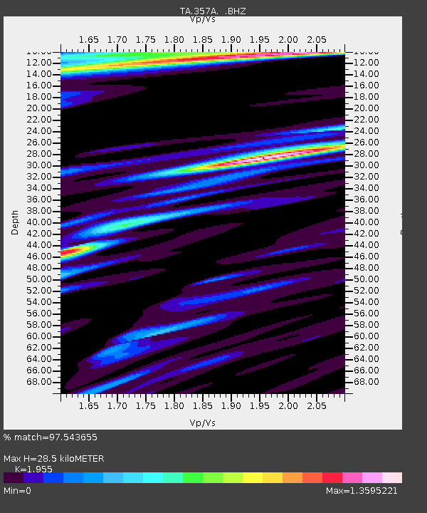
| Estimated Moho Depth: |
28.5 km |
| Estimated Crust Vp/Vs: |
1.96 |
| Assumed Crust Vp: |
5.989 km/s |
| Estimated Crust Vs: |
3.063 km/s |
| Estimated Crust Poisson's Ratio: |
0.32 |
|
| Radial Match: |
97.543655 % |
| Radial Bump: |
400 |
| Transverse Match: |
94.65517 % |
| Transverse Bump: |
400 |
| SOD ConfigId: |
512894 |
| Insert Time: |
2013-09-14 17:35:08.464 +0000 |
| GWidth: |
2.5 |
| Max Bumps: |
400 |
| Tol: |
0.001 |
|
Signal To Noise
| Channel | StoN | STA | LTA |
| TA:357A: :BHZ:20130524T05:55:36.599995Z | 10.705649 | 1.2037115E-5 | 1.1243703E-6 |
| TA:357A: :BHN:20130524T05:55:36.599995Z | 7.043477 | 4.8922484E-6 | 6.945786E-7 |
| TA:357A: :BHE:20130524T05:55:36.599995Z | 3.512785 | 2.648491E-6 | 7.5395764E-7 |
| Arrivals |
| Ps | 4.6 SECOND |
| PpPs | 14 SECOND |
| PsPs/PpSs | 18 SECOND |


