You are here: Home > Network List > TA - USArray Transportable Network (new EarthScope stations) Stations List
> Station 452A Marianna, FL, USA > Earthquake Result Viewer
452A Marianna, FL, USA - Earthquake Result Viewer
| Earthquake location: |
Sea Of Okhotsk |
| Earthquake latitude/longitude: |
54.9/153.2 |
| Earthquake time(UTC): |
2013/05/24 (144) 05:44:48 GMT |
| Earthquake Depth: |
598 km |
| Earthquake Magnitude: |
8.4 MW, 7.5 MB, 8.3 MW |
| Earthquake Catalog/Contributor: |
NEIC PDE/NEIC PDE-W |
|
| Network: |
TA USArray Transportable Network (new EarthScope stations) |
| Station: |
452A Marianna, FL, USA |
| Lat/Lon: |
30.85 N/85.18 W |
| Elevation: |
35 m |
|
| Distance: |
81.0 deg |
| Az: |
47.872 deg |
| Baz: |
330.12 deg |
| Ray Param: |
0.04604752 |
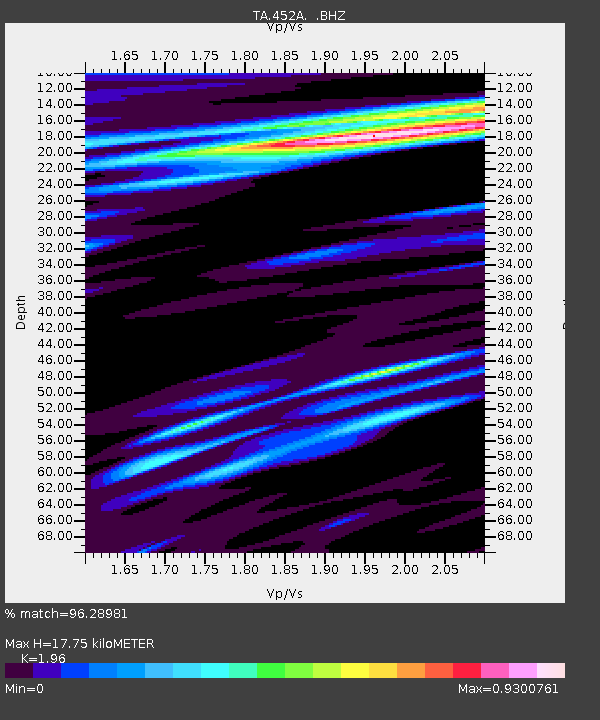
| Estimated Moho Depth: |
17.75 km |
| Estimated Crust Vp/Vs: |
1.96 |
| Assumed Crust Vp: |
6.347 km/s |
| Estimated Crust Vs: |
3.238 km/s |
| Estimated Crust Poisson's Ratio: |
0.32 |
|
| Radial Match: |
96.28981 % |
| Radial Bump: |
400 |
| Transverse Match: |
95.65841 % |
| Transverse Bump: |
400 |
| SOD ConfigId: |
512894 |
| Insert Time: |
2013-09-14 17:35:22.015 +0000 |
| GWidth: |
2.5 |
| Max Bumps: |
400 |
| Tol: |
0.001 |
|
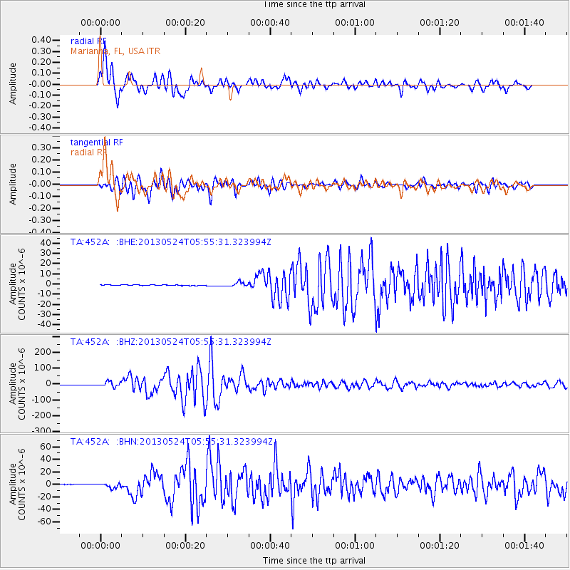
Signal To Noise
| Channel | StoN | STA | LTA |
| TA:452A: :BHZ:20130524T05:55:31.323994Z | 15.485868 | 1.66562E-5 | 1.0755742E-6 |
| TA:452A: :BHN:20130524T05:55:31.323994Z | 8.481197 | 3.8065782E-6 | 4.4882555E-7 |
| TA:452A: :BHE:20130524T05:55:31.323994Z | 6.085553 | 2.1100998E-6 | 3.4673917E-7 |
| Arrivals |
| Ps | 2.7 SECOND |
| PpPs | 8.1 SECOND |
| PsPs/PpSs | 11 SECOND |


