You are here: Home > Network List > TA - USArray Transportable Network (new EarthScope stations) Stations List
> Station 656A Willston, FL, USA > Earthquake Result Viewer
656A Willston, FL, USA - Earthquake Result Viewer
| Earthquake location: |
Sea Of Okhotsk |
| Earthquake latitude/longitude: |
54.9/153.2 |
| Earthquake time(UTC): |
2013/05/24 (144) 05:44:48 GMT |
| Earthquake Depth: |
598 km |
| Earthquake Magnitude: |
8.4 MW, 7.5 MB, 8.3 MW |
| Earthquake Catalog/Contributor: |
NEIC PDE/NEIC PDE-W |
|
| Network: |
TA USArray Transportable Network (new EarthScope stations) |
| Station: |
656A Willston, FL, USA |
| Lat/Lon: |
29.37 N/82.53 W |
| Elevation: |
28 m |
|
| Distance: |
83.4 deg |
| Az: |
46.581 deg |
| Baz: |
331.268 deg |
| Ray Param: |
0.044411372 |
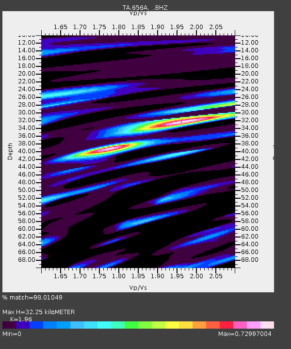
| Estimated Moho Depth: |
32.25 km |
| Estimated Crust Vp/Vs: |
1.96 |
| Assumed Crust Vp: |
5.989 km/s |
| Estimated Crust Vs: |
3.056 km/s |
| Estimated Crust Poisson's Ratio: |
0.32 |
|
| Radial Match: |
98.01049 % |
| Radial Bump: |
400 |
| Transverse Match: |
95.37867 % |
| Transverse Bump: |
400 |
| SOD ConfigId: |
512894 |
| Insert Time: |
2013-09-14 17:35:53.976 +0000 |
| GWidth: |
2.5 |
| Max Bumps: |
400 |
| Tol: |
0.001 |
|

Signal To Noise
| Channel | StoN | STA | LTA |
| TA:656A: :BHZ:20130524T05:55:43.399983Z | 15.136367 | 1.3609343E-5 | 8.9911555E-7 |
| TA:656A: :BHN:20130524T05:55:43.399983Z | 10.2626295 | 3.8226967E-6 | 3.7248708E-7 |
| TA:656A: :BHE:20130524T05:55:43.399983Z | 5.4356027 | 1.7558593E-6 | 3.2302938E-7 |
| Arrivals |
| Ps | 5.3 SECOND |
| PpPs | 16 SECOND |
| PsPs/PpSs | 21 SECOND |


