You are here: Home > Network List > TA - USArray Transportable Network (new EarthScope stations) Stations List
> Station 657A Interlachen, FL, USA > Earthquake Result Viewer
657A Interlachen, FL, USA - Earthquake Result Viewer
| Earthquake location: |
Sea Of Okhotsk |
| Earthquake latitude/longitude: |
54.9/153.2 |
| Earthquake time(UTC): |
2013/05/24 (144) 05:44:48 GMT |
| Earthquake Depth: |
598 km |
| Earthquake Magnitude: |
8.4 MW, 7.5 MB, 8.3 MW |
| Earthquake Catalog/Contributor: |
NEIC PDE/NEIC PDE-W |
|
| Network: |
TA USArray Transportable Network (new EarthScope stations) |
| Station: |
657A Interlachen, FL, USA |
| Lat/Lon: |
29.59 N/81.87 W |
| Elevation: |
34 m |
|
| Distance: |
83.5 deg |
| Az: |
45.962 deg |
| Baz: |
331.524 deg |
| Ray Param: |
0.044350654 |
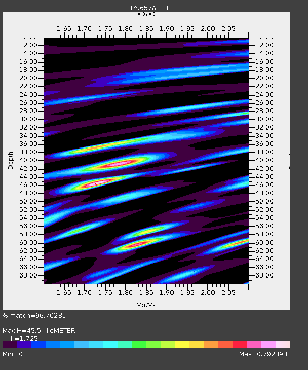
| Estimated Moho Depth: |
45.5 km |
| Estimated Crust Vp/Vs: |
1.73 |
| Assumed Crust Vp: |
6.134 km/s |
| Estimated Crust Vs: |
3.556 km/s |
| Estimated Crust Poisson's Ratio: |
0.25 |
|
| Radial Match: |
96.70281 % |
| Radial Bump: |
400 |
| Transverse Match: |
87.20147 % |
| Transverse Bump: |
400 |
| SOD ConfigId: |
512894 |
| Insert Time: |
2013-09-14 17:35:56.679 +0000 |
| GWidth: |
2.5 |
| Max Bumps: |
400 |
| Tol: |
0.001 |
|
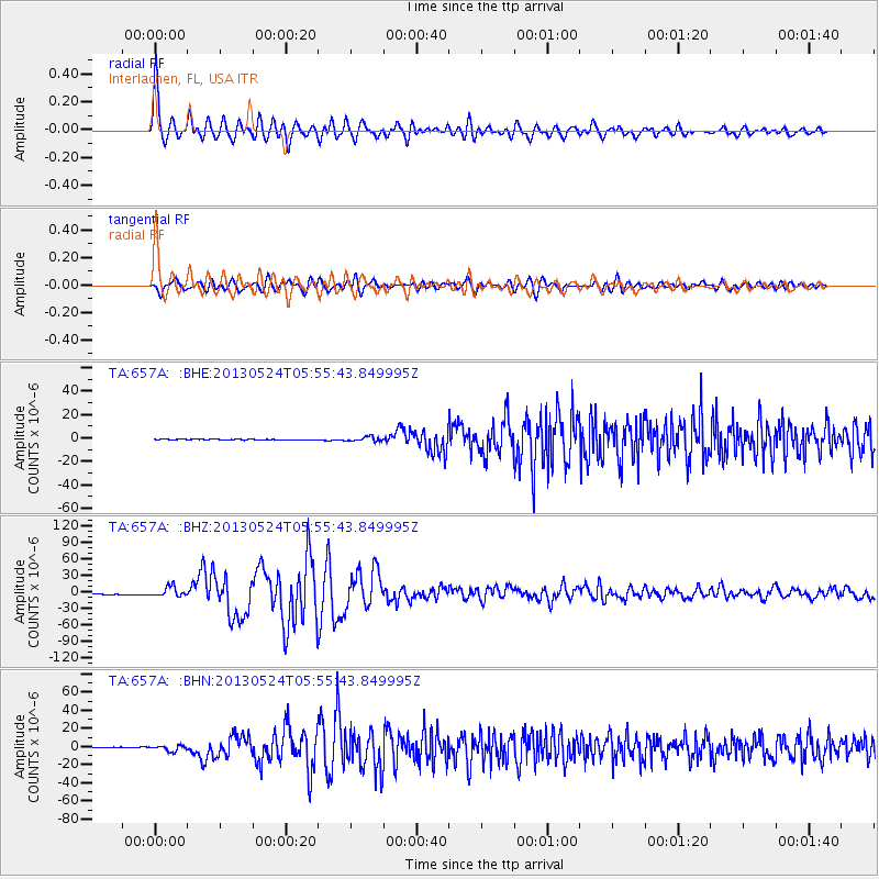
Signal To Noise
| Channel | StoN | STA | LTA |
| TA:657A: :BHZ:20130524T05:55:43.849995Z | 10.752896 | 8.721905E-6 | 8.111215E-7 |
| TA:657A: :BHN:20130524T05:55:43.849995Z | 8.648678 | 3.0987298E-6 | 3.5828944E-7 |
| TA:657A: :BHE:20130524T05:55:43.849995Z | 5.7795277 | 1.8934528E-6 | 3.2761378E-7 |
| Arrivals |
| Ps | 5.5 SECOND |
| PpPs | 20 SECOND |
| PsPs/PpSs | 25 SECOND |


