You are here: Home > Network List > TA - USArray Transportable Network (new EarthScope stations) Stations List
> Station 958A Wauchula, FL, USA > Earthquake Result Viewer
958A Wauchula, FL, USA - Earthquake Result Viewer
| Earthquake location: |
Sea Of Okhotsk |
| Earthquake latitude/longitude: |
54.9/153.2 |
| Earthquake time(UTC): |
2013/05/24 (144) 05:44:48 GMT |
| Earthquake Depth: |
598 km |
| Earthquake Magnitude: |
8.4 MW, 7.5 MB, 8.3 MW |
| Earthquake Catalog/Contributor: |
NEIC PDE/NEIC PDE-W |
|
| Network: |
TA USArray Transportable Network (new EarthScope stations) |
| Station: |
958A Wauchula, FL, USA |
| Lat/Lon: |
27.59 N/81.75 W |
| Elevation: |
30 m |
|
| Distance: |
85.3 deg |
| Az: |
46.827 deg |
| Baz: |
331.662 deg |
| Ray Param: |
0.043111164 |
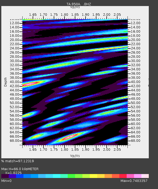
| Estimated Moho Depth: |
66.0 km |
| Estimated Crust Vp/Vs: |
1.82 |
| Assumed Crust Vp: |
6.347 km/s |
| Estimated Crust Vs: |
3.483 km/s |
| Estimated Crust Poisson's Ratio: |
0.28 |
|
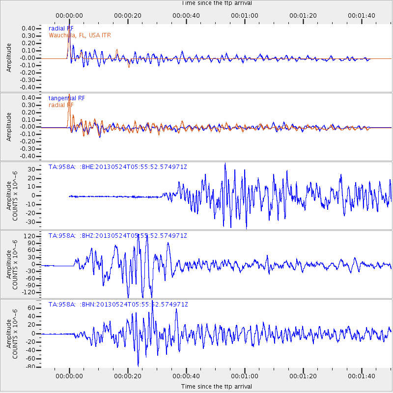
| Radial Match: |
97.12319 % |
| Radial Bump: |
400 |
| Transverse Match: |
92.75819 % |
| Transverse Bump: |
400 |
| SOD ConfigId: |
512894 |
| Insert Time: |
2013-09-14 17:36:19.204 +0000 |
| GWidth: |
2.5 |
| Max Bumps: |
400 |
| Tol: |
0.001 |
|
Signal To Noise
| Channel | StoN | STA | LTA |
| TA:958A: :BHZ:20130524T05:55:52.574971Z | 14.705263 | 1.1645174E-5 | 7.9190517E-7 |
| TA:958A: :BHN:20130524T05:55:52.574971Z | 8.18236 | 3.1713464E-6 | 3.8758338E-7 |
| TA:958A: :BHE:20130524T05:55:52.574971Z | 6.1772795 | 2.0084708E-6 | 3.251384E-7 |
| Arrivals |
| Ps | 8.7 SECOND |
| PpPs | 29 SECOND |
| PsPs/PpSs | 37 SECOND |


