You are here: Home > Network List > TA - USArray Transportable Network (new EarthScope stations) Stations List
> Station F37A Hinrichs Farm, Grantsburg, WI, USA > Earthquake Result Viewer
F37A Hinrichs Farm, Grantsburg, WI, USA - Earthquake Result Viewer
| Earthquake location: |
Sea Of Okhotsk |
| Earthquake latitude/longitude: |
54.9/153.2 |
| Earthquake time(UTC): |
2013/05/24 (144) 05:44:48 GMT |
| Earthquake Depth: |
598 km |
| Earthquake Magnitude: |
8.4 MW, 7.5 MB, 8.3 MW |
| Earthquake Catalog/Contributor: |
NEIC PDE/NEIC PDE-W |
|
| Network: |
TA USArray Transportable Network (new EarthScope stations) |
| Station: |
F37A Hinrichs Farm, Grantsburg, WI, USA |
| Lat/Lon: |
45.72 N/92.63 W |
| Elevation: |
296 m |
|
| Distance: |
65.4 deg |
| Az: |
44.686 deg |
| Baz: |
324.554 deg |
| Ray Param: |
0.05609723 |
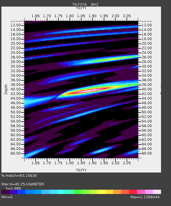
| Estimated Moho Depth: |
40.25 km |
| Estimated Crust Vp/Vs: |
1.89 |
| Assumed Crust Vp: |
6.571 km/s |
| Estimated Crust Vs: |
3.467 km/s |
| Estimated Crust Poisson's Ratio: |
0.31 |
|
| Radial Match: |
93.15638 % |
| Radial Bump: |
400 |
| Transverse Match: |
77.71647 % |
| Transverse Bump: |
400 |
| SOD ConfigId: |
512894 |
| Insert Time: |
2013-09-14 17:38:22.844 +0000 |
| GWidth: |
2.5 |
| Max Bumps: |
400 |
| Tol: |
0.001 |
|
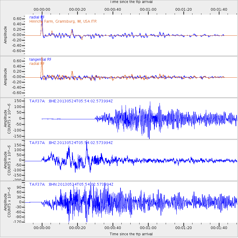
Signal To Noise
| Channel | StoN | STA | LTA |
| TA:F37A: :BHZ:20130524T05:54:02.573994Z | 12.733402 | 1.8276696E-5 | 1.4353349E-6 |
| TA:F37A: :BHN:20130524T05:54:02.573994Z | 15.167566 | 1.0294433E-5 | 6.787136E-7 |
| TA:F37A: :BHE:20130524T05:54:02.573994Z | 25.687958 | 1.2532122E-5 | 4.8785984E-7 |
| Arrivals |
| Ps | 5.7 SECOND |
| PpPs | 17 SECOND |
| PsPs/PpSs | 23 SECOND |


