You are here: Home > Network List > TA - USArray Transportable Network (new EarthScope stations) Stations List
> Station F43A Flat Rock, Escanaba, MI, USA > Earthquake Result Viewer
F43A Flat Rock, Escanaba, MI, USA - Earthquake Result Viewer
| Earthquake location: |
Sea Of Okhotsk |
| Earthquake latitude/longitude: |
54.9/153.2 |
| Earthquake time(UTC): |
2013/05/24 (144) 05:44:48 GMT |
| Earthquake Depth: |
598 km |
| Earthquake Magnitude: |
8.4 MW, 7.5 MB, 8.3 MW |
| Earthquake Catalog/Contributor: |
NEIC PDE/NEIC PDE-W |
|
| Network: |
TA USArray Transportable Network (new EarthScope stations) |
| Station: |
F43A Flat Rock, Escanaba, MI, USA |
| Lat/Lon: |
45.83 N/87.17 W |
| Elevation: |
233 m |
|
| Distance: |
67.4 deg |
| Az: |
41.174 deg |
| Baz: |
327.046 deg |
| Ray Param: |
0.054806415 |
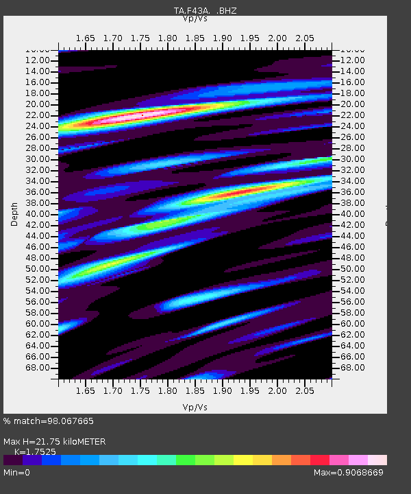
| Estimated Moho Depth: |
21.75 km |
| Estimated Crust Vp/Vs: |
1.75 |
| Assumed Crust Vp: |
6.53 km/s |
| Estimated Crust Vs: |
3.726 km/s |
| Estimated Crust Poisson's Ratio: |
0.26 |
|
| Radial Match: |
98.067665 % |
| Radial Bump: |
400 |
| Transverse Match: |
95.42609 % |
| Transverse Bump: |
400 |
| SOD ConfigId: |
512894 |
| Insert Time: |
2013-09-14 17:38:40.222 +0000 |
| GWidth: |
2.5 |
| Max Bumps: |
400 |
| Tol: |
0.001 |
|
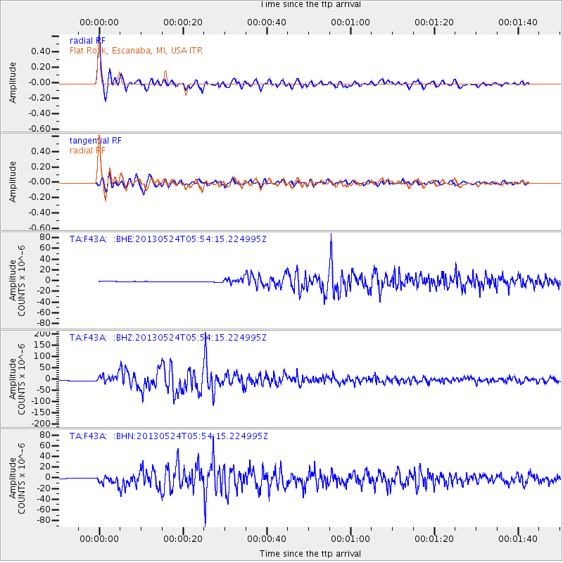
Signal To Noise
| Channel | StoN | STA | LTA |
| TA:F43A: :BHZ:20130524T05:54:15.224995Z | 15.072719 | 1.7873426E-5 | 1.1858131E-6 |
| TA:F43A: :BHN:20130524T05:54:15.224995Z | 13.380573 | 7.5021576E-6 | 5.6067535E-7 |
| TA:F43A: :BHE:20130524T05:54:15.224995Z | 12.008235 | 4.7889826E-6 | 3.9880817E-7 |
| Arrivals |
| Ps | 2.6 SECOND |
| PpPs | 8.8 SECOND |
| PsPs/PpSs | 11 SECOND |


