You are here: Home > Network List > TA - USArray Transportable Network (new EarthScope stations) Stations List
> Station H39A Augusta, WI, USA > Earthquake Result Viewer
H39A Augusta, WI, USA - Earthquake Result Viewer
| Earthquake location: |
Sea Of Okhotsk |
| Earthquake latitude/longitude: |
54.9/153.2 |
| Earthquake time(UTC): |
2013/05/24 (144) 05:44:48 GMT |
| Earthquake Depth: |
598 km |
| Earthquake Magnitude: |
8.4 MW, 7.5 MB, 8.3 MW |
| Earthquake Catalog/Contributor: |
NEIC PDE/NEIC PDE-W |
|
| Network: |
TA USArray Transportable Network (new EarthScope stations) |
| Station: |
H39A Augusta, WI, USA |
| Lat/Lon: |
44.68 N/91.28 W |
| Elevation: |
345 m |
|
| Distance: |
66.8 deg |
| Az: |
44.491 deg |
| Baz: |
325.424 deg |
| Ray Param: |
0.055220127 |
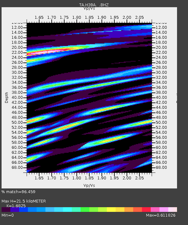
| Estimated Moho Depth: |
21.5 km |
| Estimated Crust Vp/Vs: |
1.68 |
| Assumed Crust Vp: |
6.571 km/s |
| Estimated Crust Vs: |
3.905 km/s |
| Estimated Crust Poisson's Ratio: |
0.23 |
|
| Radial Match: |
96.459 % |
| Radial Bump: |
400 |
| Transverse Match: |
87.64296 % |
| Transverse Bump: |
400 |
| SOD ConfigId: |
512894 |
| Insert Time: |
2013-09-14 17:39:47.429 +0000 |
| GWidth: |
2.5 |
| Max Bumps: |
400 |
| Tol: |
0.001 |
|
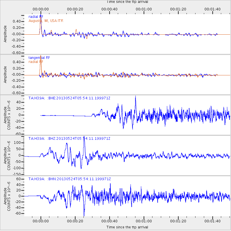
Signal To Noise
| Channel | StoN | STA | LTA |
| TA:H39A: :BHZ:20130524T05:54:11.199971Z | 8.870953 | 1.588602E-5 | 1.7907907E-6 |
| TA:H39A: :BHN:20130524T05:54:11.199971Z | 7.31498 | 5.6117733E-6 | 7.671618E-7 |
| TA:H39A: :BHE:20130524T05:54:11.199971Z | 8.69278 | 4.5137704E-6 | 5.1925514E-7 |
| Arrivals |
| Ps | 2.3 SECOND |
| PpPs | 8.4 SECOND |
| PsPs/PpSs | 11 SECOND |


