You are here: Home > Network List > TA - USArray Transportable Network (new EarthScope stations) Stations List
> Station H42A Shiocton, WI, USA > Earthquake Result Viewer
H42A Shiocton, WI, USA - Earthquake Result Viewer
| Earthquake location: |
Sea Of Okhotsk |
| Earthquake latitude/longitude: |
54.9/153.2 |
| Earthquake time(UTC): |
2013/05/24 (144) 05:44:48 GMT |
| Earthquake Depth: |
598 km |
| Earthquake Magnitude: |
8.4 MW, 7.5 MB, 8.3 MW |
| Earthquake Catalog/Contributor: |
NEIC PDE/NEIC PDE-W |
|
| Network: |
TA USArray Transportable Network (new EarthScope stations) |
| Station: |
H42A Shiocton, WI, USA |
| Lat/Lon: |
44.51 N/88.53 W |
| Elevation: |
244 m |
|
| Distance: |
68.0 deg |
| Az: |
42.827 deg |
| Baz: |
326.71 deg |
| Ray Param: |
0.054448057 |
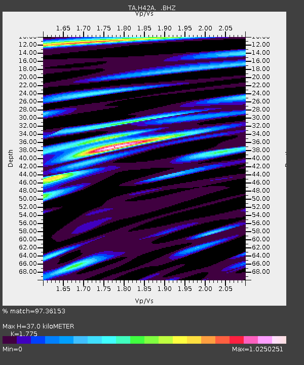
| Estimated Moho Depth: |
37.0 km |
| Estimated Crust Vp/Vs: |
1.77 |
| Assumed Crust Vp: |
6.41 km/s |
| Estimated Crust Vs: |
3.611 km/s |
| Estimated Crust Poisson's Ratio: |
0.27 |
|
| Radial Match: |
97.36153 % |
| Radial Bump: |
400 |
| Transverse Match: |
90.72708 % |
| Transverse Bump: |
400 |
| SOD ConfigId: |
512894 |
| Insert Time: |
2013-09-14 17:40:06.427 +0000 |
| GWidth: |
2.5 |
| Max Bumps: |
400 |
| Tol: |
0.001 |
|
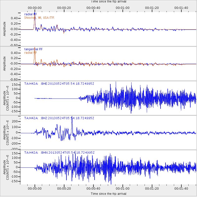
Signal To Noise
| Channel | StoN | STA | LTA |
| TA:H42A: :BHZ:20130524T05:54:18.724995Z | 17.730398 | 2.1928385E-5 | 1.2367677E-6 |
| TA:H42A: :BHN:20130524T05:54:18.724995Z | 22.952698 | 1.2836953E-5 | 5.592786E-7 |
| TA:H42A: :BHE:20130524T05:54:18.724995Z | 21.691439 | 9.89218E-6 | 4.5604077E-7 |
| Arrivals |
| Ps | 4.6 SECOND |
| PpPs | 15 SECOND |
| PsPs/PpSs | 20 SECOND |


