You are here: Home > Network List > TA - USArray Transportable Network (new EarthScope stations) Stations List
> Station H52A Wyevale, ON, CAN > Earthquake Result Viewer
H52A Wyevale, ON, CAN - Earthquake Result Viewer
| Earthquake location: |
Sea Of Okhotsk |
| Earthquake latitude/longitude: |
54.9/153.2 |
| Earthquake time(UTC): |
2013/05/24 (144) 05:44:48 GMT |
| Earthquake Depth: |
598 km |
| Earthquake Magnitude: |
8.4 MW, 7.5 MB, 8.3 MW |
| Earthquake Catalog/Contributor: |
NEIC PDE/NEIC PDE-W |
|
| Network: |
TA USArray Transportable Network (new EarthScope stations) |
| Station: |
H52A Wyevale, ON, CAN |
| Lat/Lon: |
44.64 N/79.89 W |
| Elevation: |
209 m |
|
| Distance: |
71.1 deg |
| Az: |
37.121 deg |
| Baz: |
330.765 deg |
| Ray Param: |
0.052498657 |
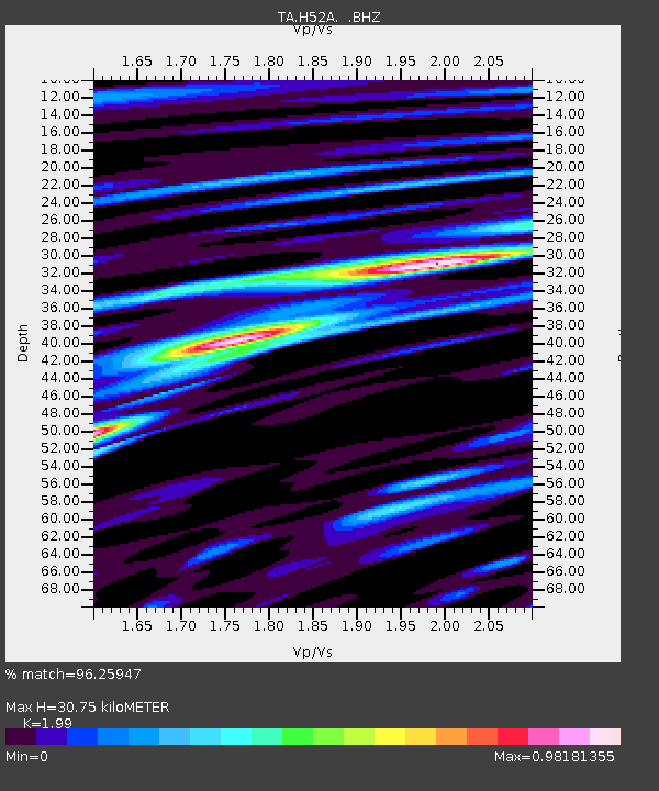
| Estimated Moho Depth: |
30.75 km |
| Estimated Crust Vp/Vs: |
1.99 |
| Assumed Crust Vp: |
6.577 km/s |
| Estimated Crust Vs: |
3.305 km/s |
| Estimated Crust Poisson's Ratio: |
0.33 |
|
| Radial Match: |
96.25947 % |
| Radial Bump: |
400 |
| Transverse Match: |
90.12351 % |
| Transverse Bump: |
400 |
| SOD ConfigId: |
512894 |
| Insert Time: |
2013-09-14 17:40:37.895 +0000 |
| GWidth: |
2.5 |
| Max Bumps: |
400 |
| Tol: |
0.001 |
|
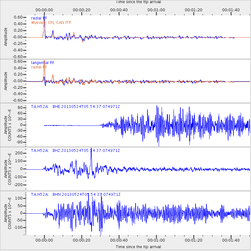
Signal To Noise
| Channel | StoN | STA | LTA |
| TA:H52A: :BHZ:20130524T05:54:37.074971Z | 22.227118 | 1.7993501E-5 | 8.0952924E-7 |
| TA:H52A: :BHN:20130524T05:54:37.074971Z | 27.303873 | 1.2376365E-5 | 4.532824E-7 |
| TA:H52A: :BHE:20130524T05:54:37.074971Z | 20.47431 | 6.41409E-6 | 3.1327502E-7 |
| Arrivals |
| Ps | 4.8 SECOND |
| PpPs | 14 SECOND |
| PsPs/PpSs | 18 SECOND |


