You are here: Home > Network List > TA - USArray Transportable Network (new EarthScope stations) Stations List
> Station J01E Myrtle Point, OR, USA > Earthquake Result Viewer
J01E Myrtle Point, OR, USA - Earthquake Result Viewer
| Earthquake location: |
Sea Of Okhotsk |
| Earthquake latitude/longitude: |
54.9/153.2 |
| Earthquake time(UTC): |
2013/05/24 (144) 05:44:48 GMT |
| Earthquake Depth: |
598 km |
| Earthquake Magnitude: |
8.4 MW, 7.5 MB, 8.3 MW |
| Earthquake Catalog/Contributor: |
NEIC PDE/NEIC PDE-W |
|
| Network: |
TA USArray Transportable Network (new EarthScope stations) |
| Station: |
J01E Myrtle Point, OR, USA |
| Lat/Lon: |
43.16 N/123.93 W |
| Elevation: |
128 m |
|
| Distance: |
52.5 deg |
| Az: |
66.253 deg |
| Baz: |
313.724 deg |
| Ray Param: |
0.064023465 |
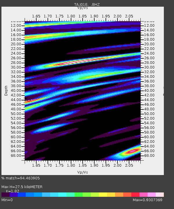
| Estimated Moho Depth: |
27.5 km |
| Estimated Crust Vp/Vs: |
1.82 |
| Assumed Crust Vp: |
6.522 km/s |
| Estimated Crust Vs: |
3.583 km/s |
| Estimated Crust Poisson's Ratio: |
0.28 |
|
| Radial Match: |
94.463905 % |
| Radial Bump: |
400 |
| Transverse Match: |
88.64389 % |
| Transverse Bump: |
400 |
| SOD ConfigId: |
512894 |
| Insert Time: |
2013-09-14 17:41:36.546 +0000 |
| GWidth: |
2.5 |
| Max Bumps: |
400 |
| Tol: |
0.001 |
|

Signal To Noise
| Channel | StoN | STA | LTA |
| TA:J01E: :BHZ:20130524T05:52:36.849995Z | 10.266976 | 4.647854E-5 | 4.5269944E-6 |
| TA:J01E: :BHN:20130524T05:52:36.849995Z | 6.197489 | 1.143862E-5 | 1.8456864E-6 |
| TA:J01E: :BHE:20130524T05:52:36.849995Z | 6.4517665 | 1.17979625E-5 | 1.8286406E-6 |
| Arrivals |
| Ps | 3.6 SECOND |
| PpPs | 11 SECOND |
| PsPs/PpSs | 15 SECOND |


