You are here: Home > Network List > TA - USArray Transportable Network (new EarthScope stations) Stations List
> Station J41A Loganville, WI, USA > Earthquake Result Viewer
J41A Loganville, WI, USA - Earthquake Result Viewer
| Earthquake location: |
Sea Of Okhotsk |
| Earthquake latitude/longitude: |
54.9/153.2 |
| Earthquake time(UTC): |
2013/05/24 (144) 05:44:48 GMT |
| Earthquake Depth: |
598 km |
| Earthquake Magnitude: |
8.4 MW, 7.5 MB, 8.3 MW |
| Earthquake Catalog/Contributor: |
NEIC PDE/NEIC PDE-W |
|
| Network: |
TA USArray Transportable Network (new EarthScope stations) |
| Station: |
J41A Loganville, WI, USA |
| Lat/Lon: |
43.37 N/90.01 W |
| Elevation: |
360 m |
|
| Distance: |
68.4 deg |
| Az: |
44.468 deg |
| Baz: |
326.295 deg |
| Ray Param: |
0.054220393 |
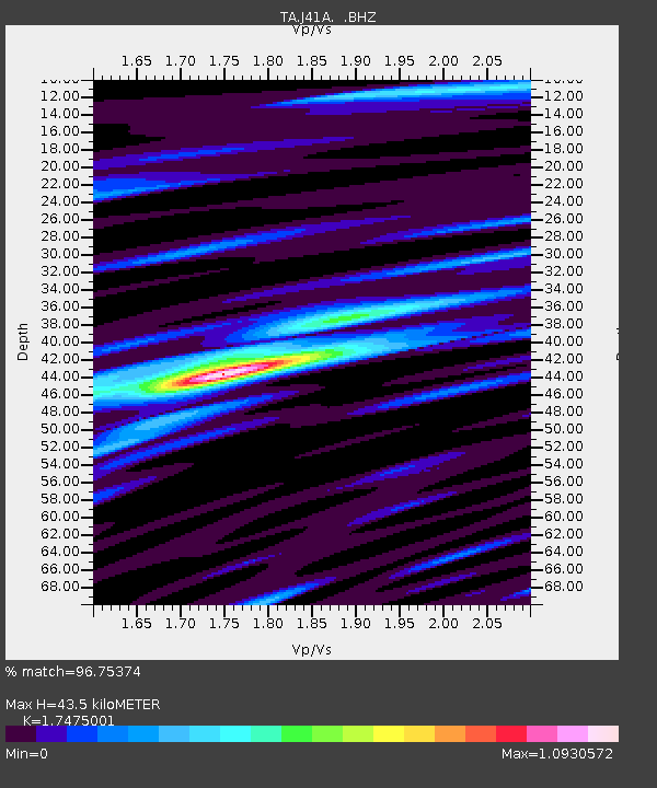
| Estimated Moho Depth: |
43.5 km |
| Estimated Crust Vp/Vs: |
1.75 |
| Assumed Crust Vp: |
6.53 km/s |
| Estimated Crust Vs: |
3.737 km/s |
| Estimated Crust Poisson's Ratio: |
0.26 |
|
| Radial Match: |
96.75374 % |
| Radial Bump: |
400 |
| Transverse Match: |
92.08794 % |
| Transverse Bump: |
400 |
| SOD ConfigId: |
512894 |
| Insert Time: |
2013-09-14 17:41:48.587 +0000 |
| GWidth: |
2.5 |
| Max Bumps: |
400 |
| Tol: |
0.001 |
|
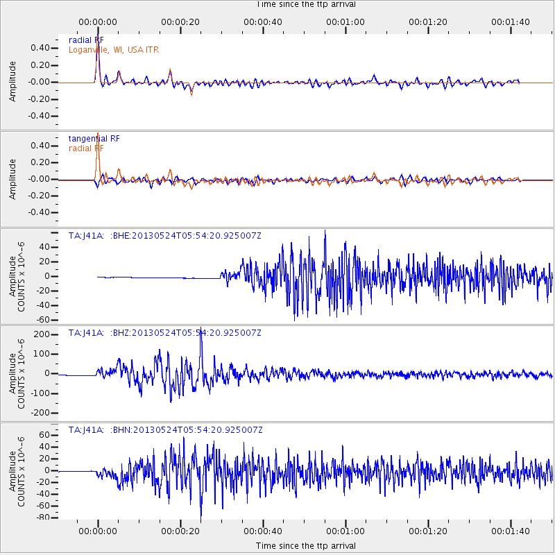
Signal To Noise
| Channel | StoN | STA | LTA |
| TA:J41A: :BHZ:20130524T05:54:20.925007Z | 15.963914 | 2.170113E-5 | 1.3593865E-6 |
| TA:J41A: :BHN:20130524T05:54:20.925007Z | 11.26613 | 6.8367144E-6 | 6.0683783E-7 |
| TA:J41A: :BHE:20130524T05:54:20.925007Z | 14.277303 | 6.3412003E-6 | 4.4414557E-7 |
| Arrivals |
| Ps | 5.2 SECOND |
| PpPs | 18 SECOND |
| PsPs/PpSs | 23 SECOND |


