You are here: Home > Network List > TA - USArray Transportable Network (new EarthScope stations) Stations List
> Station K39A Oelwein, IA, USA > Earthquake Result Viewer
K39A Oelwein, IA, USA - Earthquake Result Viewer
| Earthquake location: |
Sea Of Okhotsk |
| Earthquake latitude/longitude: |
54.9/153.2 |
| Earthquake time(UTC): |
2013/05/24 (144) 05:44:48 GMT |
| Earthquake Depth: |
598 km |
| Earthquake Magnitude: |
8.4 MW, 7.5 MB, 8.3 MW |
| Earthquake Catalog/Contributor: |
NEIC PDE/NEIC PDE-W |
|
| Network: |
TA USArray Transportable Network (new EarthScope stations) |
| Station: |
K39A Oelwein, IA, USA |
| Lat/Lon: |
42.71 N/91.89 W |
| Elevation: |
332 m |
|
| Distance: |
68.1 deg |
| Az: |
46.092 deg |
| Baz: |
325.622 deg |
| Ray Param: |
0.054361295 |
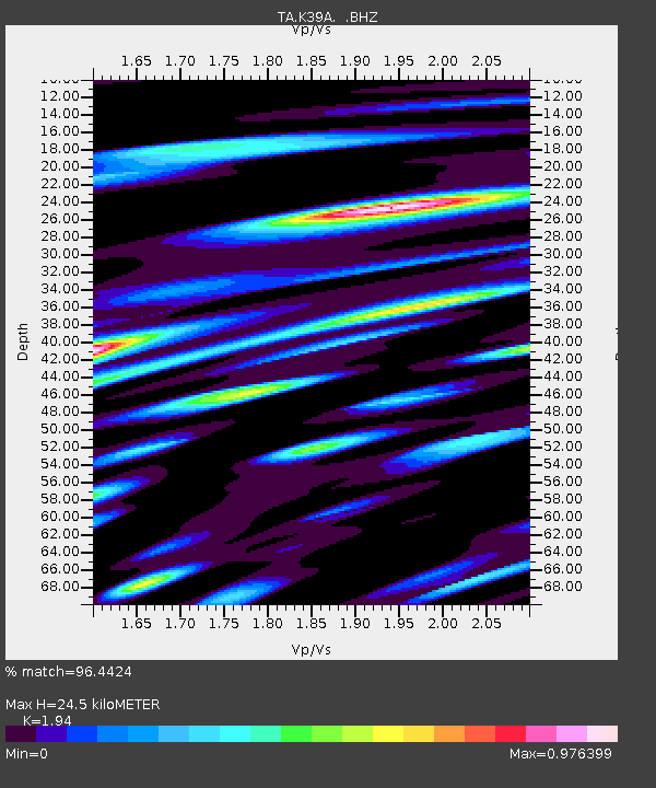
| Estimated Moho Depth: |
24.5 km |
| Estimated Crust Vp/Vs: |
1.94 |
| Assumed Crust Vp: |
6.53 km/s |
| Estimated Crust Vs: |
3.366 km/s |
| Estimated Crust Poisson's Ratio: |
0.32 |
|
| Radial Match: |
96.4424 % |
| Radial Bump: |
400 |
| Transverse Match: |
91.35116 % |
| Transverse Bump: |
400 |
| SOD ConfigId: |
512894 |
| Insert Time: |
2013-09-14 17:42:25.501 +0000 |
| GWidth: |
2.5 |
| Max Bumps: |
400 |
| Tol: |
0.001 |
|
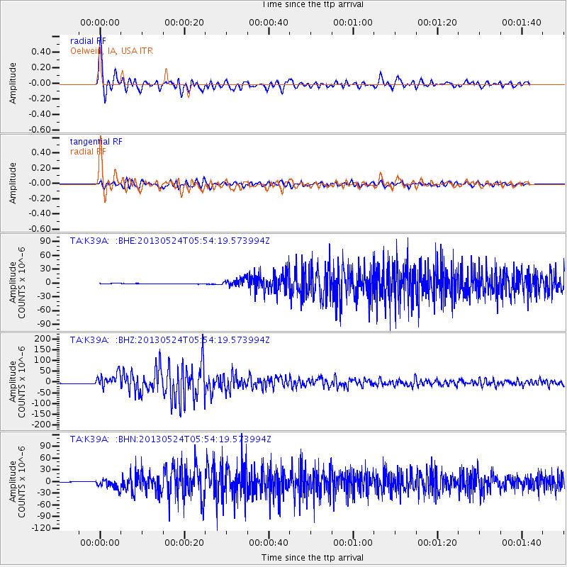
Signal To Noise
| Channel | StoN | STA | LTA |
| TA:K39A: :BHZ:20130524T05:54:19.573994Z | 22.902554 | 3.2553708E-5 | 1.4214008E-6 |
| TA:K39A: :BHN:20130524T05:54:19.573994Z | 19.468382 | 1.2595792E-5 | 6.4698713E-7 |
| TA:K39A: :BHE:20130524T05:54:19.573994Z | 17.579884 | 8.101084E-6 | 4.6081558E-7 |
| Arrivals |
| Ps | 3.6 SECOND |
| PpPs | 11 SECOND |
| PsPs/PpSs | 14 SECOND |


