You are here: Home > Network List > TA - USArray Transportable Network (new EarthScope stations) Stations List
> Station K48A Perry, MI, USA > Earthquake Result Viewer
K48A Perry, MI, USA - Earthquake Result Viewer

| Earthquake location: |
Sea Of Okhotsk |
| Earthquake latitude/longitude: |
54.9/153.2 |
| Earthquake time(UTC): |
2013/05/24 (144) 05:44:48 GMT |
| Earthquake Depth: |
598 km |
| Earthquake Magnitude: |
8.4 MW, 7.5 MB, 8.3 MW |
| Earthquake Catalog/Contributor: |
NEIC PDE/NEIC PDE-W |
|
| Network: |
TA USArray Transportable Network (new EarthScope stations) |
| Station: |
K48A Perry, MI, USA |
| Lat/Lon: |
42.80 N/84.12 W |
| Elevation: |
273 m |
|
| Distance: |
71.1 deg |
| Az: |
40.9 deg |
| Baz: |
329.073 deg |
| Ray Param: |
0.052465092 |
| Estimated Moho Depth: |
26.0 km |
| Estimated Crust Vp/Vs: |
2.01 |
| Assumed Crust Vp: |
6.483 km/s |
| Estimated Crust Vs: |
3.233 km/s |
| Estimated Crust Poisson's Ratio: |
0.33 |
|
| Radial Match: |
98.78273 % |
| Radial Bump: |
400 |
| Transverse Match: |
97.54678 % |
| Transverse Bump: |
400 |
| SOD ConfigId: |
512894 |
| Insert Time: |
2013-09-14 17:42:40.836 +0000 |
| GWidth: |
2.5 |
| Max Bumps: |
400 |
| Tol: |
0.001 |
|
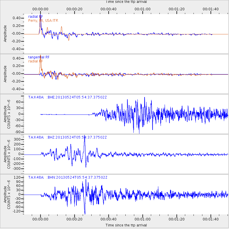
Signal To Noise
| Channel | StoN | STA | LTA |
| TA:K48A: :BHZ:20130524T05:54:37.37502Z | 18.47933 | 1.9286223E-5 | 1.0436645E-6 |
| TA:K48A: :BHN:20130524T05:54:37.37502Z | 15.295767 | 6.8184695E-6 | 4.4577493E-7 |
| TA:K48A: :BHE:20130524T05:54:37.37502Z | 13.200517 | 4.769098E-6 | 3.6128114E-7 |
| Arrivals |
| Ps | 4.2 SECOND |
| PpPs | 12 SECOND |
| PsPs/PpSs | 16 SECOND |


