You are here: Home > Network List > TA - USArray Transportable Network (new EarthScope stations) Stations List
> Station M43A Waltham Township, Utica, IL, USA > Earthquake Result Viewer
M43A Waltham Township, Utica, IL, USA - Earthquake Result Viewer

| Earthquake location: |
Sea Of Okhotsk |
| Earthquake latitude/longitude: |
54.9/153.2 |
| Earthquake time(UTC): |
2013/05/24 (144) 05:44:48 GMT |
| Earthquake Depth: |
598 km |
| Earthquake Magnitude: |
8.4 MW, 7.5 MB, 8.3 MW |
| Earthquake Catalog/Contributor: |
NEIC PDE/NEIC PDE-W |
|
| Network: |
TA USArray Transportable Network (new EarthScope stations) |
| Station: |
M43A Waltham Township, Utica, IL, USA |
| Lat/Lon: |
41.44 N/88.96 W |
| Elevation: |
190 m |
|
| Distance: |
70.4 deg |
| Az: |
44.9 deg |
| Baz: |
327.156 deg |
| Ray Param: |
0.052938186 |
| Estimated Moho Depth: |
29.5 km |
| Estimated Crust Vp/Vs: |
2.10 |
| Assumed Crust Vp: |
6.498 km/s |
| Estimated Crust Vs: |
3.098 km/s |
| Estimated Crust Poisson's Ratio: |
0.35 |
|
| Radial Match: |
95.74485 % |
| Radial Bump: |
400 |
| Transverse Match: |
89.28336 % |
| Transverse Bump: |
400 |
| SOD ConfigId: |
512894 |
| Insert Time: |
2013-09-14 17:43:53.519 +0000 |
| GWidth: |
2.5 |
| Max Bumps: |
400 |
| Tol: |
0.001 |
|
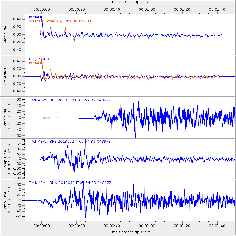
Signal To Noise
| Channel | StoN | STA | LTA |
| TA:M43A: :BHZ:20130524T05:54:33.04897Z | 17.272945 | 2.2557595E-5 | 1.3059496E-6 |
| TA:M43A: :BHN:20130524T05:54:33.04897Z | 11.171284 | 6.498687E-6 | 5.8173146E-7 |
| TA:M43A: :BHE:20130524T05:54:33.04897Z | 13.723464 | 5.6554427E-6 | 4.1210023E-7 |
| Arrivals |
| Ps | 5.1 SECOND |
| PpPs | 14 SECOND |
| PsPs/PpSs | 19 SECOND |


