You are here: Home > Network List > WY - Yellowstone Wyoming Seismic Network Stations List
> Station YFT Old Faithful, YNP, WY, USA > Earthquake Result Viewer
YFT Old Faithful, YNP, WY, USA - Earthquake Result Viewer
| Earthquake location: |
Hokkaido, Japan Region |
| Earthquake latitude/longitude: |
41.1/142.2 |
| Earthquake time(UTC): |
2014/08/10 (222) 03:43:16 GMT |
| Earthquake Depth: |
38 km |
| Earthquake Magnitude: |
6.0 MB |
| Earthquake Catalog/Contributor: |
NEIC PDE/NEIC COMCAT |
|
| Network: |
WY Yellowstone Wyoming Seismic Network |
| Station: |
YFT Old Faithful, YNP, WY, USA |
| Lat/Lon: |
44.45 N/110.84 W |
| Elevation: |
2292 m |
|
| Distance: |
72.6 deg |
| Az: |
45.876 deg |
| Baz: |
310.8 deg |
| Ray Param: |
0.053504657 |
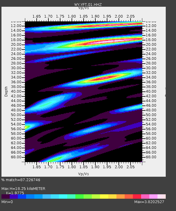
| Estimated Moho Depth: |
18.25 km |
| Estimated Crust Vp/Vs: |
1.98 |
| Assumed Crust Vp: |
6.35 km/s |
| Estimated Crust Vs: |
3.211 km/s |
| Estimated Crust Poisson's Ratio: |
0.33 |
|
| Radial Match: |
87.226746 % |
| Radial Bump: |
400 |
| Transverse Match: |
80.984116 % |
| Transverse Bump: |
400 |
| SOD ConfigId: |
3390531 |
| Insert Time: |
2019-04-13 06:48:38.385 +0000 |
| GWidth: |
2.5 |
| Max Bumps: |
400 |
| Tol: |
0.001 |
|

Signal To Noise
| Channel | StoN | STA | LTA |
| WY:YFT:01:HHZ:20140810T03:54:08.828997Z | 6.3496284 | 1.5514436E-8 | 2.4433613E-9 |
| WY:YFT:01:HHN:20140810T03:54:08.828997Z | 1.8453043 | 6.9810806E-9 | 3.7831596E-9 |
| WY:YFT:01:HHE:20140810T03:54:08.828997Z | 2.82511 | 6.239291E-9 | 2.2085125E-9 |
| Arrivals |
| Ps | 2.9 SECOND |
| PpPs | 8.3 SECOND |
| PsPs/PpSs | 11 SECOND |


