You are here: Home > Network List > TA - USArray Transportable Network (new EarthScope stations) Stations List
> Station M46A Old House Field, Plymouth, IN, USA > Earthquake Result Viewer
M46A Old House Field, Plymouth, IN, USA - Earthquake Result Viewer
| Earthquake location: |
Sea Of Okhotsk |
| Earthquake latitude/longitude: |
54.9/153.2 |
| Earthquake time(UTC): |
2013/05/24 (144) 05:44:48 GMT |
| Earthquake Depth: |
598 km |
| Earthquake Magnitude: |
8.4 MW, 7.5 MB, 8.3 MW |
| Earthquake Catalog/Contributor: |
NEIC PDE/NEIC PDE-W |
|
| Network: |
TA USArray Transportable Network (new EarthScope stations) |
| Station: |
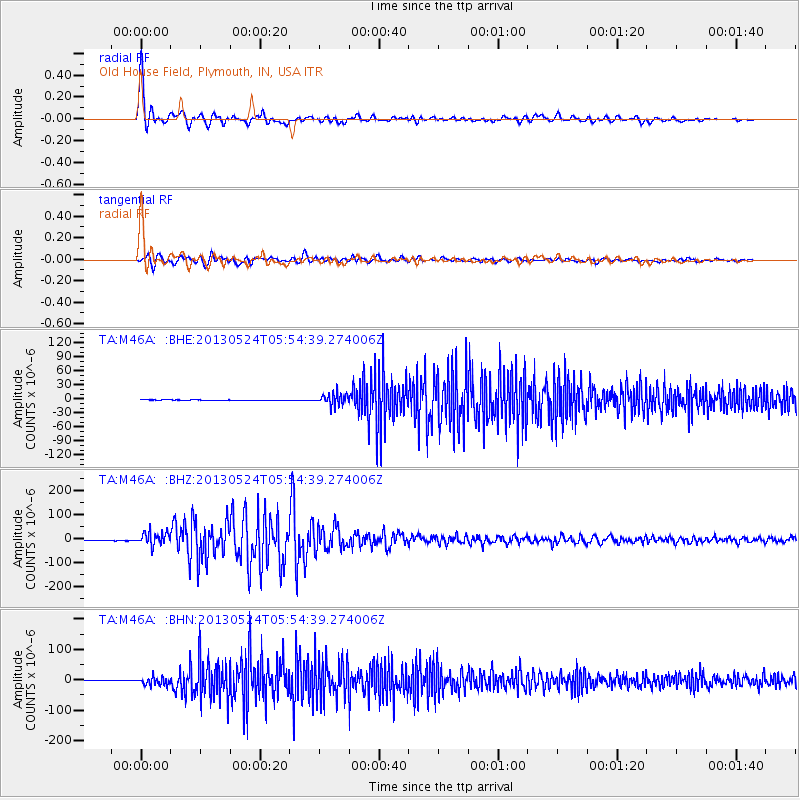
M46A Old House Field, Plymouth, IN, USA |
| Lat/Lon: |
41.41 N/86.35 W |
| Elevation: |
242 m |
|
| Distance: |
71.5 deg |
| Az: |
43.163 deg |
| Baz: |
328.307 deg |
| Ray Param: |
0.052255824 |
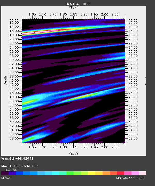
| Estimated Moho Depth: |
16.5 km |
| Estimated Crust Vp/Vs: |
1.66 |
| Assumed Crust Vp: |
6.498 km/s |
| Estimated Crust Vs: |
3.914 km/s |
| Estimated Crust Poisson's Ratio: |
0.22 |
|
| Radial Match: |
98.42948 % |
| Radial Bump: |
397 |
| Transverse Match: |
94.68456 % |
| Transverse Bump: |
400 |
| SOD ConfigId: |
512894 |
| Insert Time: |
2013-09-14 17:44:01.894 +0000 |
| GWidth: |
2.5 |
| Max Bumps: |
400 |
| Tol: |
0.001 |
|
Signal To Noise
| Channel | StoN | STA | LTA |
| TA:M46A: :BHZ:20130524T05:54:39.274006Z | 23.702356 | 2.7474238E-5 | 1.1591353E-6 |
| TA:M46A: :BHN:20130524T05:54:39.274006Z | 26.231781 | 1.3136801E-5 | 5.007971E-7 |
| TA:M46A: :BHE:20130524T05:54:39.274006Z | 30.870813 | 1.2276563E-5 | 3.9767542E-7 |
| Arrivals |
| Ps | 1.7 SECOND |
| PpPs | 6.5 SECOND |
| PsPs/PpSs | 8.3 SECOND |


