You are here: Home > Network List > TA - USArray Transportable Network (new EarthScope stations) Stations List
> Station MSTX Muleshoe, TX, USA > Earthquake Result Viewer
MSTX Muleshoe, TX, USA - Earthquake Result Viewer
| Earthquake location: |
Sea Of Okhotsk |
| Earthquake latitude/longitude: |
54.9/153.2 |
| Earthquake time(UTC): |
2013/05/24 (144) 05:44:48 GMT |
| Earthquake Depth: |
598 km |
| Earthquake Magnitude: |
8.4 MW, 7.5 MB, 8.3 MW |
| Earthquake Catalog/Contributor: |
NEIC PDE/NEIC PDE-W |
|
| Network: |
TA USArray Transportable Network (new EarthScope stations) |
| Station: |
MSTX Muleshoe, TX, USA |
| Lat/Lon: |
33.97 N/102.77 W |
| Elevation: |
1167 m |
|
| Distance: |
70.3 deg |
| Az: |
58.949 deg |
| Baz: |
323.45 deg |
| Ray Param: |
0.053028703 |
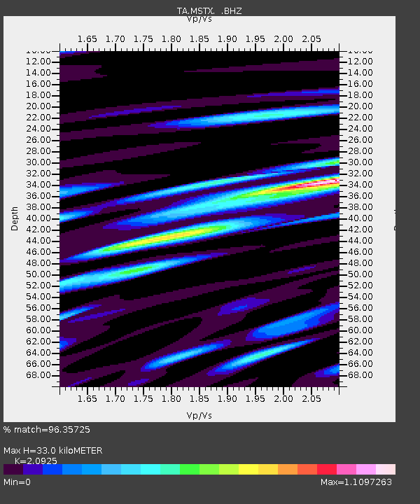
| Estimated Moho Depth: |
33.0 km |
| Estimated Crust Vp/Vs: |
2.09 |
| Assumed Crust Vp: |
6.129 km/s |
| Estimated Crust Vs: |
2.929 km/s |
| Estimated Crust Poisson's Ratio: |
0.35 |
|
| Radial Match: |
96.35725 % |
| Radial Bump: |
400 |
| Transverse Match: |
92.433136 % |
| Transverse Bump: |
400 |
| SOD ConfigId: |
512894 |
| Insert Time: |
2013-09-14 17:44:36.534 +0000 |
| GWidth: |
2.5 |
| Max Bumps: |
400 |
| Tol: |
0.001 |
|
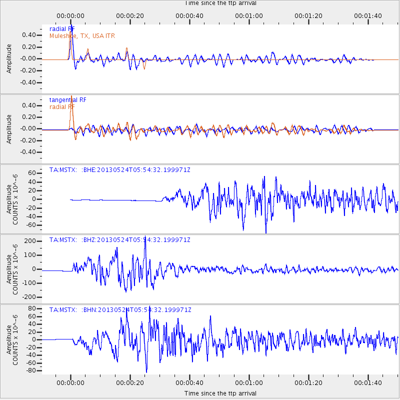
Signal To Noise
| Channel | StoN | STA | LTA |
| TA:MSTX: :BHZ:20130524T05:54:32.199971Z | 11.157379 | 2.2717684E-5 | 2.0361128E-6 |
| TA:MSTX: :BHN:20130524T05:54:32.199971Z | 8.881377 | 6.776831E-6 | 7.630383E-7 |
| TA:MSTX: :BHE:20130524T05:54:32.199971Z | 6.3031707 | 3.7201519E-6 | 5.902033E-7 |
| Arrivals |
| Ps | 6.0 SECOND |
| PpPs | 16 SECOND |
| PsPs/PpSs | 22 SECOND |


