You are here: Home > Network List > TA - USArray Transportable Network (new EarthScope stations) Stations List
> Station N51A Ashland, OH, USA > Earthquake Result Viewer
N51A Ashland, OH, USA - Earthquake Result Viewer
| Earthquake location: |
Sea Of Okhotsk |
| Earthquake latitude/longitude: |
54.9/153.2 |
| Earthquake time(UTC): |
2013/05/24 (144) 05:44:48 GMT |
| Earthquake Depth: |
598 km |
| Earthquake Magnitude: |
8.4 MW, 7.5 MB, 8.3 MW |
| Earthquake Catalog/Contributor: |
NEIC PDE/NEIC PDE-W |
|
| Network: |
TA USArray Transportable Network (new EarthScope stations) |
| Station: |
N51A Ashland, OH, USA |
| Lat/Lon: |
40.92 N/82.37 W |
| Elevation: |
343 m |
|
| Distance: |
73.4 deg |
| Az: |
40.719 deg |
| Baz: |
330.178 deg |
| Ray Param: |
0.051010914 |
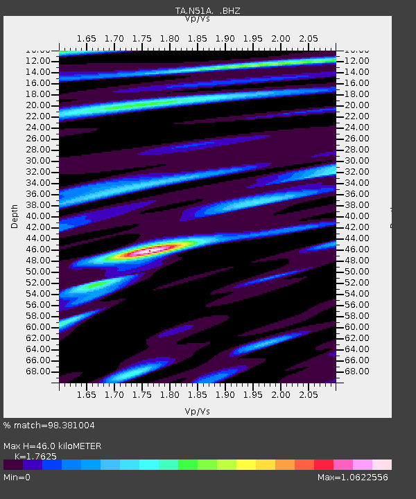
| Estimated Moho Depth: |
46.0 km |
| Estimated Crust Vp/Vs: |
1.76 |
| Assumed Crust Vp: |
6.498 km/s |
| Estimated Crust Vs: |
3.687 km/s |
| Estimated Crust Poisson's Ratio: |
0.26 |
|
| Radial Match: |
98.381004 % |
| Radial Bump: |
400 |
| Transverse Match: |
97.57056 % |
| Transverse Bump: |
400 |
| SOD ConfigId: |
512894 |
| Insert Time: |
2013-09-14 17:45:10.636 +0000 |
| GWidth: |
2.5 |
| Max Bumps: |
400 |
| Tol: |
0.001 |
|

Signal To Noise
| Channel | StoN | STA | LTA |
| TA:N51A: :BHZ:20130524T05:54:50.474019Z | 28.05481 | 2.665212E-5 | 9.5000183E-7 |
| TA:N51A: :BHN:20130524T05:54:50.474019Z | 25.898968 | 1.1514073E-5 | 4.445765E-7 |
| TA:N51A: :BHE:20130524T05:54:50.474019Z | 15.935952 | 4.900503E-6 | 3.075124E-7 |
| Arrivals |
| Ps | 5.6 SECOND |
| PpPs | 19 SECOND |
| PsPs/PpSs | 25 SECOND |


