You are here: Home > Network List > XD14 - Illuminating the architecture of the greater Mount St. Helens magmatic systems f Stations List
> Station MD09 "Mount St Helens, WA" > Earthquake Result Viewer
MD09 "Mount St Helens, WA" - Earthquake Result Viewer
| Earthquake location: |
Hokkaido, Japan Region |
| Earthquake latitude/longitude: |
41.1/142.2 |
| Earthquake time(UTC): |
2014/08/10 (222) 03:43:16 GMT |
| Earthquake Depth: |
38 km |
| Earthquake Magnitude: |
6.0 MB |
| Earthquake Catalog/Contributor: |
NEIC PDE/NEIC COMCAT |
|
| Network: |
XD Illuminating the architecture of the greater Mount St. Helens magmatic systems f |
| Station: |
MD09 "Mount St Helens, WA" |
| Lat/Lon: |
46.50 N/121.71 W |
| Elevation: |
959 m |
|
| Distance: |
65.3 deg |
| Az: |
49.124 deg |
| Baz: |
304.233 deg |
| Ray Param: |
0.058313023 |
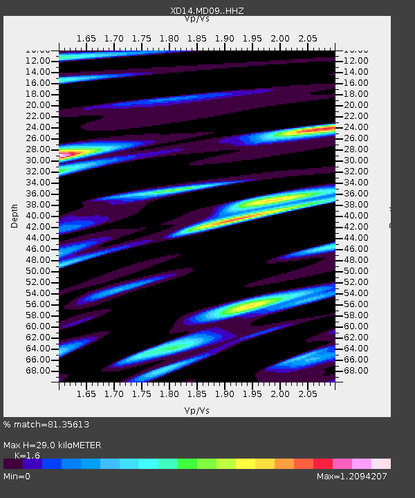
| Estimated Moho Depth: |
29.0 km |
| Estimated Crust Vp/Vs: |
1.60 |
| Assumed Crust Vp: |
6.597 km/s |
| Estimated Crust Vs: |
4.123 km/s |
| Estimated Crust Poisson's Ratio: |
0.18 |
|
| Radial Match: |
81.35613 % |
| Radial Bump: |
400 |
| Transverse Match: |
75.233376 % |
| Transverse Bump: |
400 |
| SOD ConfigId: |
3390531 |
| Insert Time: |
2019-04-13 06:49:06.598 +0000 |
| GWidth: |
2.5 |
| Max Bumps: |
400 |
| Tol: |
0.001 |
|

Signal To Noise
| Channel | StoN | STA | LTA |
| XD:MD09: :HHZ:20140810T03:53:23.52498Z | 3.2496574 | 2.8272203E-7 | 8.7000565E-8 |
| XD:MD09: :HHN:20140810T03:53:23.52498Z | 2.0238516 | 1.7624272E-7 | 8.7082825E-8 |
| XD:MD09: :HHE:20140810T03:53:23.52498Z | 1.8925183 | 1.5744139E-7 | 8.319147E-8 |
| Arrivals |
| Ps | 2.8 SECOND |
| PpPs | 11 SECOND |
| PsPs/PpSs | 14 SECOND |


