You are here: Home > Network List > TA - USArray Transportable Network (new EarthScope stations) Stations List
> Station O03E Paynes Creek, CA, USA > Earthquake Result Viewer
O03E Paynes Creek, CA, USA - Earthquake Result Viewer
| Earthquake location: |
Sea Of Okhotsk |
| Earthquake latitude/longitude: |
54.9/153.2 |
| Earthquake time(UTC): |
2013/05/24 (144) 05:44:48 GMT |
| Earthquake Depth: |
598 km |
| Earthquake Magnitude: |
8.4 MW, 7.5 MB, 8.3 MW |
| Earthquake Catalog/Contributor: |
NEIC PDE/NEIC PDE-W |
|
| Network: |
TA USArray Transportable Network (new EarthScope stations) |
| Station: |
O03E Paynes Creek, CA, USA |
| Lat/Lon: |
40.29 N/121.80 W |
| Elevation: |
967 m |
|
| Distance: |
55.6 deg |
| Az: |
67.379 deg |
| Baz: |
315.798 deg |
| Ray Param: |
0.06209873 |
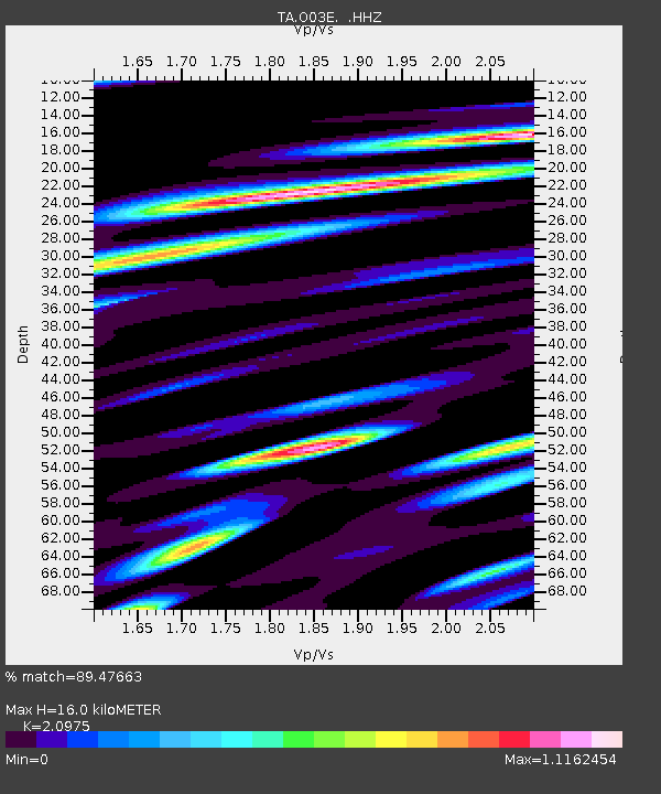
| Estimated Moho Depth: |
16.0 km |
| Estimated Crust Vp/Vs: |
2.10 |
| Assumed Crust Vp: |
6.566 km/s |
| Estimated Crust Vs: |
3.13 km/s |
| Estimated Crust Poisson's Ratio: |
0.35 |
|
| Radial Match: |
89.47663 % |
| Radial Bump: |
400 |
| Transverse Match: |
84.04142 % |
| Transverse Bump: |
400 |
| SOD ConfigId: |
512894 |
| Insert Time: |
2013-09-14 17:45:37.350 +0000 |
| GWidth: |
2.5 |
| Max Bumps: |
400 |
| Tol: |
0.001 |
|
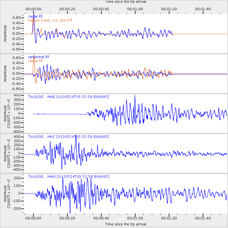
Signal To Noise
| Channel | StoN | STA | LTA |
| TA:O03E: :HHZ:20130524T05:52:58.849995Z | 10.615021 | 4.245322E-5 | 3.9993533E-6 |
| TA:O03E: :HHN:20130524T05:52:58.849995Z | 13.247892 | 1.8814115E-5 | 1.4201592E-6 |
| TA:O03E: :HHE:20130524T05:52:58.849995Z | 14.896111 | 2.1592647E-5 | 1.4495494E-6 |
| Arrivals |
| Ps | 2.8 SECOND |
| PpPs | 7.2 SECOND |
| PsPs/PpSs | 10 SECOND |


