You are here: Home > Network List > TA - USArray Transportable Network (new EarthScope stations) Stations List
> Station O52A Adamsville, OH, USA > Earthquake Result Viewer
O52A Adamsville, OH, USA - Earthquake Result Viewer
| Earthquake location: |
Sea Of Okhotsk |
| Earthquake latitude/longitude: |
54.9/153.2 |
| Earthquake time(UTC): |
2013/05/24 (144) 05:44:48 GMT |
| Earthquake Depth: |
598 km |
| Earthquake Magnitude: |
8.4 MW, 7.5 MB, 8.3 MW |
| Earthquake Catalog/Contributor: |
NEIC PDE/NEIC PDE-W |
|
| Network: |
TA USArray Transportable Network (new EarthScope stations) |
| Station: |
O52A Adamsville, OH, USA |
| Lat/Lon: |
40.12 N/81.84 W |
| Elevation: |
331 m |
|
| Distance: |
74.3 deg |
| Az: |
40.76 deg |
| Baz: |
330.538 deg |
| Ray Param: |
0.0504369 |
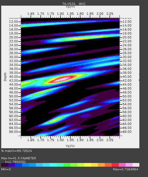
| Estimated Moho Depth: |
41.5 km |
| Estimated Crust Vp/Vs: |
1.80 |
| Assumed Crust Vp: |
6.483 km/s |
| Estimated Crust Vs: |
3.611 km/s |
| Estimated Crust Poisson's Ratio: |
0.27 |
|
| Radial Match: |
98.78524 % |
| Radial Bump: |
359 |
| Transverse Match: |
97.202255 % |
| Transverse Bump: |
400 |
| SOD ConfigId: |
512894 |
| Insert Time: |
2013-09-14 17:45:57.508 +0000 |
| GWidth: |
2.5 |
| Max Bumps: |
400 |
| Tol: |
0.001 |
|
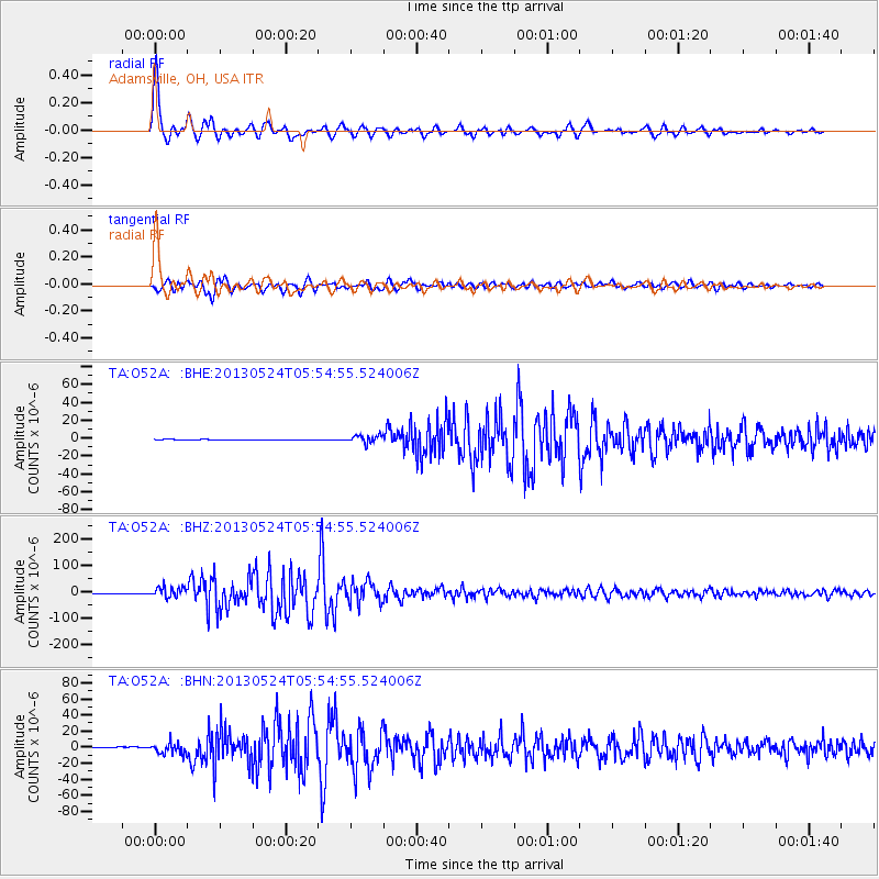
Signal To Noise
| Channel | StoN | STA | LTA |
| TA:O52A: :BHZ:20130524T05:54:55.524006Z | 19.673689 | 1.8852037E-5 | 9.58236E-7 |
| TA:O52A: :BHN:20130524T05:54:55.524006Z | 15.017809 | 6.724992E-6 | 4.4780114E-7 |
| TA:O52A: :BHE:20130524T05:54:55.524006Z | 15.666726 | 4.209576E-6 | 2.6869532E-7 |
| Arrivals |
| Ps | 5.2 SECOND |
| PpPs | 17 SECOND |
| PsPs/PpSs | 23 SECOND |


