You are here: Home > Network List > TA - USArray Transportable Network (new EarthScope stations) Stations List
> Station O57A Amberson, PA, USA > Earthquake Result Viewer
O57A Amberson, PA, USA - Earthquake Result Viewer
| Earthquake location: |
Sea Of Okhotsk |
| Earthquake latitude/longitude: |
54.9/153.2 |
| Earthquake time(UTC): |
2013/05/24 (144) 05:44:48 GMT |
| Earthquake Depth: |
598 km |
| Earthquake Magnitude: |
8.4 MW, 7.5 MB, 8.3 MW |
| Earthquake Catalog/Contributor: |
NEIC PDE/NEIC PDE-W |
|
| Network: |
TA USArray Transportable Network (new EarthScope stations) |
| Station: |
O57A Amberson, PA, USA |
| Lat/Lon: |
40.21 N/77.64 W |
| Elevation: |
377 m |
|
| Distance: |
75.8 deg |
| Az: |
37.785 deg |
| Baz: |
332.47 deg |
| Ray Param: |
0.049496226 |
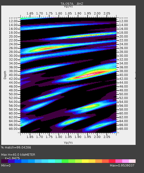
| Estimated Moho Depth: |
40.0 km |
| Estimated Crust Vp/Vs: |
1.95 |
| Assumed Crust Vp: |
6.121 km/s |
| Estimated Crust Vs: |
3.143 km/s |
| Estimated Crust Poisson's Ratio: |
0.32 |
|
| Radial Match: |
99.04286 % |
| Radial Bump: |
393 |
| Transverse Match: |
97.6444 % |
| Transverse Bump: |
400 |
| SOD ConfigId: |
512894 |
| Insert Time: |
2013-09-14 17:46:08.356 +0000 |
| GWidth: |
2.5 |
| Max Bumps: |
400 |
| Tol: |
0.001 |
|
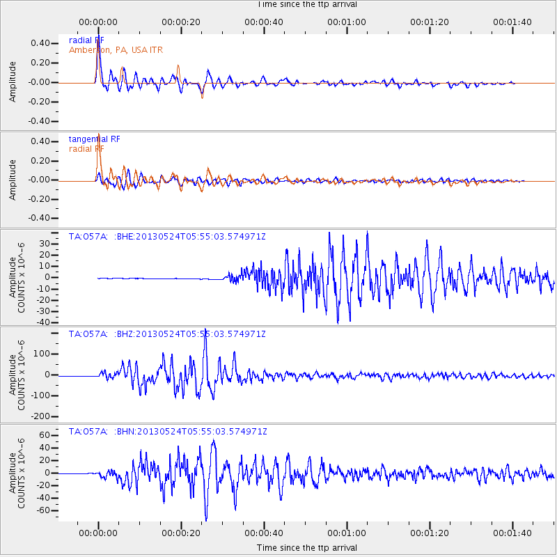
Signal To Noise
| Channel | StoN | STA | LTA |
| TA:O57A: :BHZ:20130524T05:55:03.574971Z | 17.41809 | 1.3166126E-5 | 7.55888E-7 |
| TA:O57A: :BHN:20130524T05:55:03.574971Z | 15.005214 | 5.255373E-6 | 3.5023643E-7 |
| TA:O57A: :BHE:20130524T05:55:03.574971Z | 12.326351 | 2.797376E-6 | 2.2694276E-7 |
| Arrivals |
| Ps | 6.3 SECOND |
| PpPs | 19 SECOND |
| PsPs/PpSs | 25 SECOND |


