You are here: Home > Network List > TA - USArray Transportable Network (new EarthScope stations) Stations List
> Station O59A Robesonia, PA, USA > Earthquake Result Viewer
O59A Robesonia, PA, USA - Earthquake Result Viewer
| Earthquake location: |
Sea Of Okhotsk |
| Earthquake latitude/longitude: |
54.9/153.2 |
| Earthquake time(UTC): |
2013/05/24 (144) 05:44:48 GMT |
| Earthquake Depth: |
598 km |
| Earthquake Magnitude: |
8.4 MW, 7.5 MB, 8.3 MW |
| Earthquake Catalog/Contributor: |
NEIC PDE/NEIC PDE-W |
|
| Network: |
TA USArray Transportable Network (new EarthScope stations) |
| Station: |
O59A Robesonia, PA, USA |
| Lat/Lon: |
40.31 N/76.19 W |
| Elevation: |
334 m |
|
| Distance: |
76.2 deg |
| Az: |
36.721 deg |
| Baz: |
333.146 deg |
| Ray Param: |
0.049227577 |
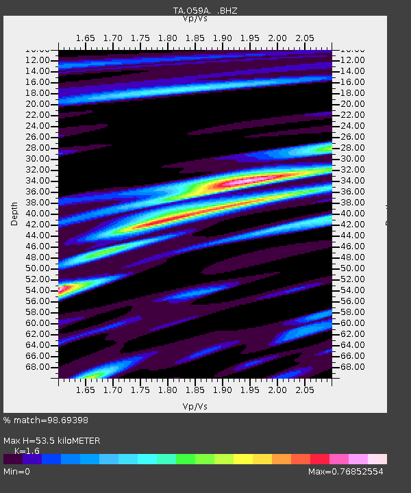
| Estimated Moho Depth: |
53.5 km |
| Estimated Crust Vp/Vs: |
1.60 |
| Assumed Crust Vp: |
6.121 km/s |
| Estimated Crust Vs: |
3.825 km/s |
| Estimated Crust Poisson's Ratio: |
0.18 |
|
| Radial Match: |
98.69398 % |
| Radial Bump: |
400 |
| Transverse Match: |
95.741615 % |
| Transverse Bump: |
400 |
| SOD ConfigId: |
512894 |
| Insert Time: |
2013-09-14 17:46:13.229 +0000 |
| GWidth: |
2.5 |
| Max Bumps: |
400 |
| Tol: |
0.001 |
|

Signal To Noise
| Channel | StoN | STA | LTA |
| TA:O59A: :BHZ:20130524T05:55:05.873982Z | 10.359521 | 8.824004E-6 | 8.5177726E-7 |
| TA:O59A: :BHN:20130524T05:55:05.873982Z | 7.6824784 | 2.7371404E-6 | 3.5628352E-7 |
| TA:O59A: :BHE:20130524T05:55:05.873982Z | 8.404412 | 1.6855703E-6 | 2.0055778E-7 |
| Arrivals |
| Ps | 5.4 SECOND |
| PpPs | 22 SECOND |
| PsPs/PpSs | 27 SECOND |


