You are here: Home > Network List > TA - USArray Transportable Network (new EarthScope stations) Stations List
> Station Q46A CEJHS Indians, Carlisle, IN, USA > Earthquake Result Viewer
Q46A CEJHS Indians, Carlisle, IN, USA - Earthquake Result Viewer
| Earthquake location: |
Sea Of Okhotsk |
| Earthquake latitude/longitude: |
54.9/153.2 |
| Earthquake time(UTC): |
2013/05/24 (144) 05:44:48 GMT |
| Earthquake Depth: |
598 km |
| Earthquake Magnitude: |
8.4 MW, 7.5 MB, 8.3 MW |
| Earthquake Catalog/Contributor: |
NEIC PDE/NEIC PDE-W |
|
| Network: |
TA USArray Transportable Network (new EarthScope stations) |
| Station: |
Q46A CEJHS Indians, Carlisle, IN, USA |
| Lat/Lon: |
39.02 N/87.36 W |
| Elevation: |
164 m |
|
| Distance: |
73.1 deg |
| Az: |
45.165 deg |
| Baz: |
328.269 deg |
| Ray Param: |
0.05122481 |
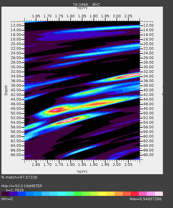
| Estimated Moho Depth: |
53.0 km |
| Estimated Crust Vp/Vs: |
1.78 |
| Assumed Crust Vp: |
6.444 km/s |
| Estimated Crust Vs: |
3.615 km/s |
| Estimated Crust Poisson's Ratio: |
0.27 |
|
| Radial Match: |
97.57228 % |
| Radial Bump: |
400 |
| Transverse Match: |
90.32111 % |
| Transverse Bump: |
400 |
| SOD ConfigId: |
512894 |
| Insert Time: |
2013-09-14 17:47:03.064 +0000 |
| GWidth: |
2.5 |
| Max Bumps: |
400 |
| Tol: |
0.001 |
|

Signal To Noise
| Channel | StoN | STA | LTA |
| TA:Q46A: :BHZ:20130524T05:54:48.574971Z | 10.986851 | 1.7382365E-5 | 1.5821062E-6 |
| TA:Q46A: :BHN:20130524T05:54:48.574971Z | 9.567325 | 6.4176556E-6 | 6.70789E-7 |
| TA:Q46A: :BHE:20130524T05:54:48.574971Z | 9.240451 | 4.2376814E-6 | 4.5860116E-7 |
| Arrivals |
| Ps | 6.6 SECOND |
| PpPs | 22 SECOND |
| PsPs/PpSs | 29 SECOND |


