You are here: Home > Network List > TA - USArray Transportable Network (new EarthScope stations) Stations List
> Station R59A King George, VA, USA > Earthquake Result Viewer
R59A King George, VA, USA - Earthquake Result Viewer
| Earthquake location: |
Sea Of Okhotsk |
| Earthquake latitude/longitude: |
54.9/153.2 |
| Earthquake time(UTC): |
2013/05/24 (144) 05:44:48 GMT |
| Earthquake Depth: |
598 km |
| Earthquake Magnitude: |
8.4 MW, 7.5 MB, 8.3 MW |
| Earthquake Catalog/Contributor: |
NEIC PDE/NEIC PDE-W |
|
| Network: |
TA USArray Transportable Network (new EarthScope stations) |
| Station: |
R59A King George, VA, USA |
| Lat/Lon: |
38.20 N/77.12 W |
| Elevation: |
35 m |
|
| Distance: |
77.8 deg |
| Az: |
38.363 deg |
| Baz: |
332.929 deg |
| Ray Param: |
0.048215978 |
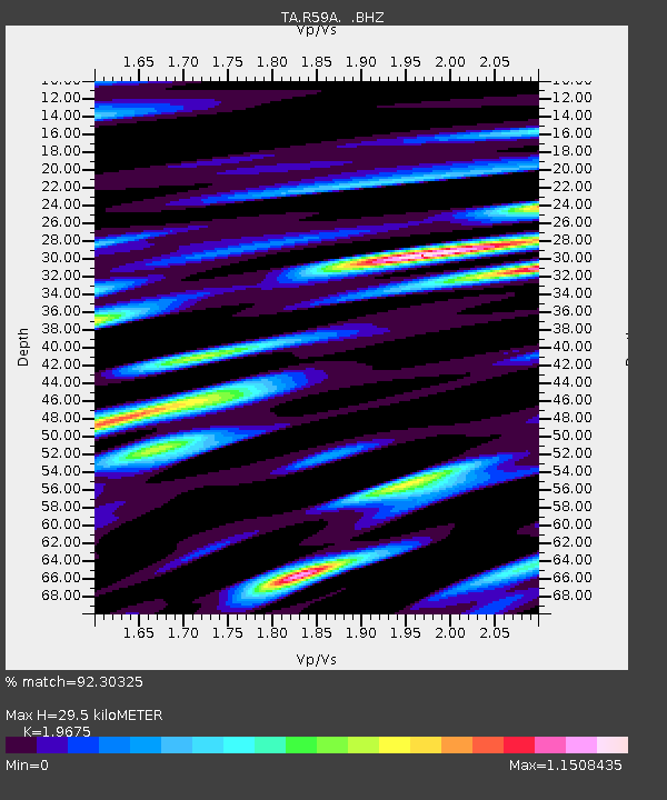
| Estimated Moho Depth: |
29.5 km |
| Estimated Crust Vp/Vs: |
1.97 |
| Assumed Crust Vp: |
6.419 km/s |
| Estimated Crust Vs: |
3.263 km/s |
| Estimated Crust Poisson's Ratio: |
0.33 |
|
| Radial Match: |
92.30325 % |
| Radial Bump: |
400 |
| Transverse Match: |
88.009705 % |
| Transverse Bump: |
400 |
| SOD ConfigId: |
512894 |
| Insert Time: |
2013-09-14 17:48:16.357 +0000 |
| GWidth: |
2.5 |
| Max Bumps: |
400 |
| Tol: |
0.001 |
|
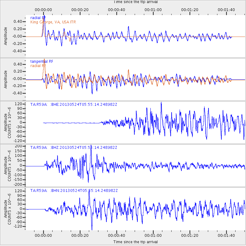
Signal To Noise
| Channel | StoN | STA | LTA |
| TA:R59A: :BHZ:20130524T05:55:14.248982Z | 24.433428 | 1.7392513E-5 | 7.118327E-7 |
| TA:R59A: :BHN:20130524T05:55:14.248982Z | 11.143365 | 5.911734E-6 | 5.3051605E-7 |
| TA:R59A: :BHE:20130524T05:55:14.248982Z | 9.190092 | 4.738984E-6 | 5.156623E-7 |
| Arrivals |
| Ps | 4.6 SECOND |
| PpPs | 13 SECOND |
| PsPs/PpSs | 18 SECOND |


