You are here: Home > Network List > TA - USArray Transportable Network (new EarthScope stations) Stations List
> Station S53A Williamson, WV, USA > Earthquake Result Viewer
S53A Williamson, WV, USA - Earthquake Result Viewer
| Earthquake location: |
Sea Of Okhotsk |
| Earthquake latitude/longitude: |
54.9/153.2 |
| Earthquake time(UTC): |
2013/05/24 (144) 05:44:48 GMT |
| Earthquake Depth: |
598 km |
| Earthquake Magnitude: |
8.4 MW, 7.5 MB, 8.3 MW |
| Earthquake Catalog/Contributor: |
NEIC PDE/NEIC PDE-W |
|
| Network: |
TA USArray Transportable Network (new EarthScope stations) |
| Station: |
S53A Williamson, WV, USA |
| Lat/Lon: |
37.68 N/82.13 W |
| Elevation: |
564 m |
|
| Distance: |
76.3 deg |
| Az: |
42.196 deg |
| Baz: |
330.72 deg |
| Ray Param: |
0.04913809 |
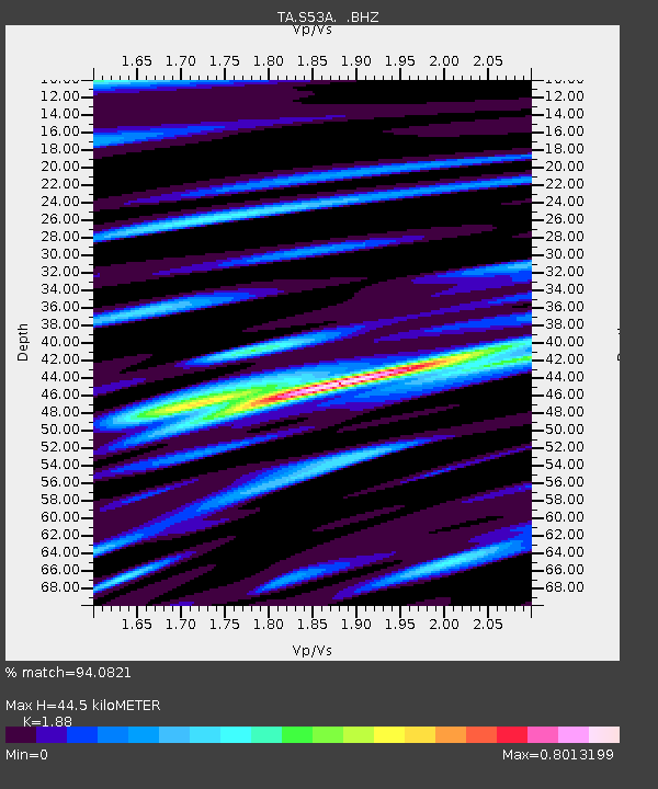
| Estimated Moho Depth: |
44.5 km |
| Estimated Crust Vp/Vs: |
1.88 |
| Assumed Crust Vp: |
6.476 km/s |
| Estimated Crust Vs: |
3.445 km/s |
| Estimated Crust Poisson's Ratio: |
0.30 |
|
| Radial Match: |
94.0821 % |
| Radial Bump: |
400 |
| Transverse Match: |
87.59835 % |
| Transverse Bump: |
400 |
| SOD ConfigId: |
512894 |
| Insert Time: |
2013-09-14 17:48:46.858 +0000 |
| GWidth: |
2.5 |
| Max Bumps: |
400 |
| Tol: |
0.001 |
|

Signal To Noise
| Channel | StoN | STA | LTA |
| TA:S53A: :BHZ:20130524T05:55:06.62502Z | 13.671182 | 1.3146601E-5 | 9.616288E-7 |
| TA:S53A: :BHN:20130524T05:55:06.62502Z | 12.2957115 | 5.3421004E-6 | 4.3446857E-7 |
| TA:S53A: :BHE:20130524T05:55:06.62502Z | 13.067289 | 3.7244931E-6 | 2.8502416E-7 |
| Arrivals |
| Ps | 6.2 SECOND |
| PpPs | 19 SECOND |
| PsPs/PpSs | 25 SECOND |


