You are here: Home > Network List > TA - USArray Transportable Network (new EarthScope stations) Stations List
> Station T50A Nancy, KY, USA > Earthquake Result Viewer
T50A Nancy, KY, USA - Earthquake Result Viewer
| Earthquake location: |
Sea Of Okhotsk |
| Earthquake latitude/longitude: |
54.9/153.2 |
| Earthquake time(UTC): |
2013/05/24 (144) 05:44:48 GMT |
| Earthquake Depth: |
598 km |
| Earthquake Magnitude: |
8.4 MW, 7.5 MB, 8.3 MW |
| Earthquake Catalog/Contributor: |
NEIC PDE/NEIC PDE-W |
|
| Network: |
TA USArray Transportable Network (new EarthScope stations) |
| Station: |
T50A Nancy, KY, USA |
| Lat/Lon: |
37.02 N/84.84 W |
| Elevation: |
302 m |
|
| Distance: |
75.8 deg |
| Az: |
44.466 deg |
| Baz: |
329.628 deg |
| Ray Param: |
0.04946292 |
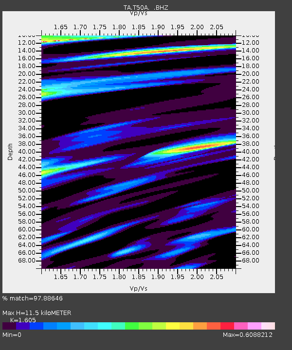
| Estimated Moho Depth: |
11.5 km |
| Estimated Crust Vp/Vs: |
1.61 |
| Assumed Crust Vp: |
6.476 km/s |
| Estimated Crust Vs: |
4.035 km/s |
| Estimated Crust Poisson's Ratio: |
0.18 |
|
| Radial Match: |
97.88646 % |
| Radial Bump: |
400 |
| Transverse Match: |
97.15291 % |
| Transverse Bump: |
400 |
| SOD ConfigId: |
512894 |
| Insert Time: |
2013-09-14 17:49:32.345 +0000 |
| GWidth: |
2.5 |
| Max Bumps: |
400 |
| Tol: |
0.001 |
|
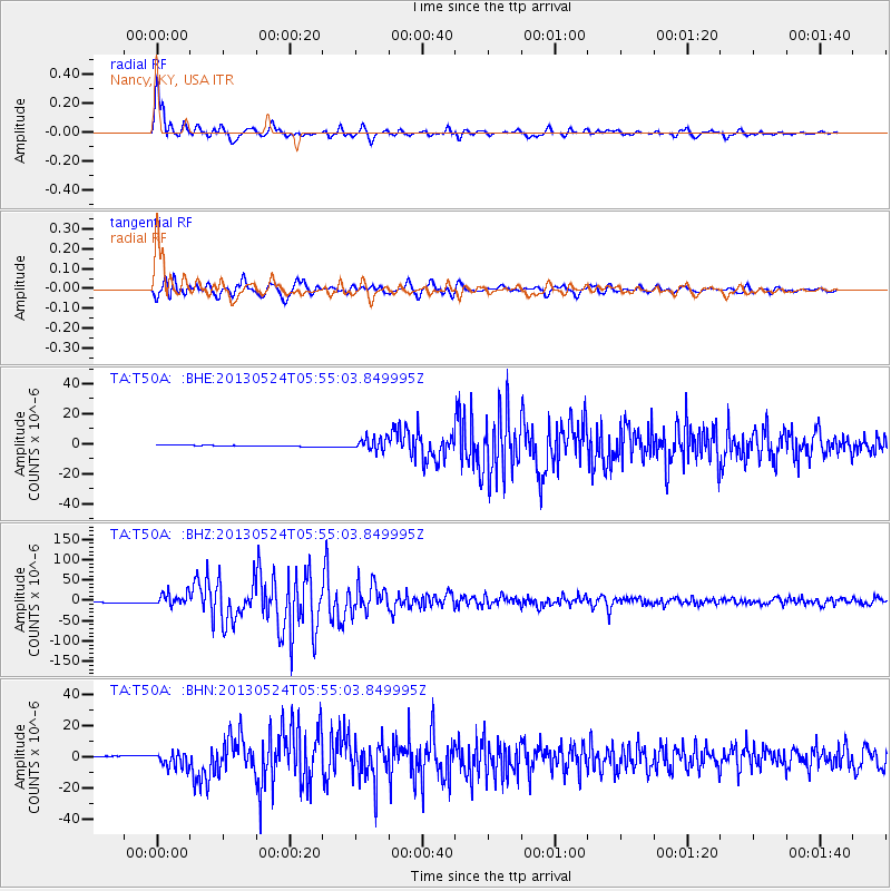
Signal To Noise
| Channel | StoN | STA | LTA |
| TA:T50A: :BHZ:20130524T05:55:03.849995Z | 14.144835 | 1.5394537E-5 | 1.0883504E-6 |
| TA:T50A: :BHN:20130524T05:55:03.849995Z | 10.313158 | 4.702163E-6 | 4.5593825E-7 |
| TA:T50A: :BHE:20130524T05:55:03.849995Z | 11.790872 | 4.1194708E-6 | 3.4937798E-7 |
| Arrivals |
| Ps | 1.1 SECOND |
| PpPs | 4.5 SECOND |
| PsPs/PpSs | 5.6 SECOND |


