You are here: Home > Network List > TA - USArray Transportable Network (new EarthScope stations) Stations List
> Station U53A Fall Branch, TN, USA > Earthquake Result Viewer
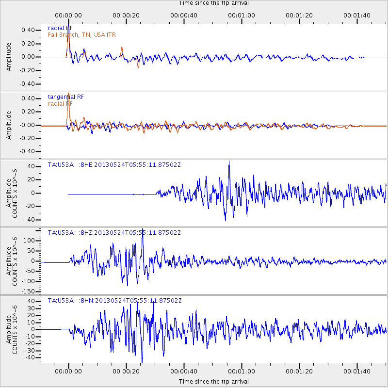
U53A Fall Branch, TN, USA - Earthquake Result Viewer

| Earthquake location: |
Sea Of Okhotsk |
| Earthquake latitude/longitude: |
54.9/153.2 |
| Earthquake time(UTC): |
2013/05/24 (144) 05:44:48 GMT |
| Earthquake Depth: |
598 km |
| Earthquake Magnitude: |
8.4 MW, 7.5 MB, 8.3 MW |
| Earthquake Catalog/Contributor: |
NEIC PDE/NEIC PDE-W |
|
| Network: |
TA USArray Transportable Network (new EarthScope stations) |
| Station: |
U53A Fall Branch, TN, USA |
| Lat/Lon: |
36.36 N/82.58 W |
| Elevation: |
559 m |
|
| Distance: |
77.3 deg |
| Az: |
43.18 deg |
| Baz: |
330.675 deg |
| Ray Param: |
0.048505493 |
| Estimated Moho Depth: |
45.5 km |
| Estimated Crust Vp/Vs: |
1.77 |
| Assumed Crust Vp: |
6.476 km/s |
| Estimated Crust Vs: |
3.654 km/s |
| Estimated Crust Poisson's Ratio: |
0.27 |
|
| Radial Match: |
98.39189 % |
| Radial Bump: |
400 |
| Transverse Match: |
95.82028 % |
| Transverse Bump: |
400 |
| SOD ConfigId: |
512894 |
| Insert Time: |
2013-09-14 17:50:36.122 +0000 |
| GWidth: |
2.5 |
| Max Bumps: |
400 |
| Tol: |
0.001 |
|
Signal To Noise
| Channel | StoN | STA | LTA |
| TA:U53A: :BHZ:20130524T05:55:11.87502Z | 13.341091 | 1.2844519E-5 | 9.627787E-7 |
| TA:U53A: :BHN:20130524T05:55:11.87502Z | 11.069378 | 4.158802E-6 | 3.7570328E-7 |
| TA:U53A: :BHE:20130524T05:55:11.87502Z | 11.263926 | 2.4493636E-6 | 2.1745204E-7 |
| Arrivals |
| Ps | 5.6 SECOND |
| PpPs | 19 SECOND |
| PsPs/PpSs | 25 SECOND |


