You are here: Home > Network List > TA - USArray Transportable Network (new EarthScope stations) Stations List
> Station U58A Oxford, NC, USA > Earthquake Result Viewer
U58A Oxford, NC, USA - Earthquake Result Viewer
| Earthquake location: |
Sea Of Okhotsk |
| Earthquake latitude/longitude: |
54.9/153.2 |
| Earthquake time(UTC): |
2013/05/24 (144) 05:44:48 GMT |
| Earthquake Depth: |
598 km |
| Earthquake Magnitude: |
8.4 MW, 7.5 MB, 8.3 MW |
| Earthquake Catalog/Contributor: |
NEIC PDE/NEIC PDE-W |
|
| Network: |
TA USArray Transportable Network (new EarthScope stations) |
| Station: |
U58A Oxford, NC, USA |
| Lat/Lon: |
36.39 N/78.55 W |
| Elevation: |
169 m |
|
| Distance: |
78.8 deg |
| Az: |
40.245 deg |
| Baz: |
332.447 deg |
| Ray Param: |
0.047506437 |
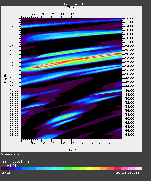
| Estimated Moho Depth: |
33.0 km |
| Estimated Crust Vp/Vs: |
1.73 |
| Assumed Crust Vp: |
6.419 km/s |
| Estimated Crust Vs: |
3.711 km/s |
| Estimated Crust Poisson's Ratio: |
0.25 |
|
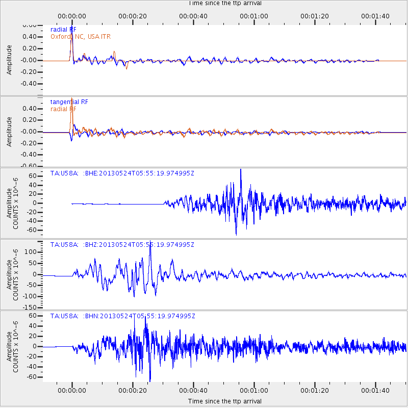
| Radial Match: |
98.88111 % |
| Radial Bump: |
358 |
| Transverse Match: |
97.63508 % |
| Transverse Bump: |
400 |
| SOD ConfigId: |
512894 |
| Insert Time: |
2013-09-14 17:50:47.141 +0000 |
| GWidth: |
2.5 |
| Max Bumps: |
400 |
| Tol: |
0.001 |
|
Signal To Noise
| Channel | StoN | STA | LTA |
| TA:U58A: :BHZ:20130524T05:55:19.974995Z | 13.085534 | 9.902401E-6 | 7.5674416E-7 |
| TA:U58A: :BHN:20130524T05:55:19.974995Z | 12.288469 | 4.034371E-6 | 3.2830545E-7 |
| TA:U58A: :BHE:20130524T05:55:19.974995Z | 15.158673 | 3.5585317E-6 | 2.3475219E-7 |
| Arrivals |
| Ps | 3.9 SECOND |
| PpPs | 14 SECOND |
| PsPs/PpSs | 18 SECOND |


